Gandom Beryan , also known as roasted wheat and burnt sand, is located 80 kilometers north of Shahdad (Khabis) in Kerman province and covers an area of about 200 square kilometers. The surface of granitic wheat is covered with volcanic black basaltic rocks and lava. Behind the Salt River are sandy slopes to the north, known as the Goddess of Gunpowder. Behind Godard is a barren plain of volcanic sediments on the east side, followed by the Brian Wheat Plain. On the plain lies a layer of basalt that makes it difficult to cross. In many articles, newspapers and websites have referred to this as the hottest spot on earth that has no credibility.
Read More ...
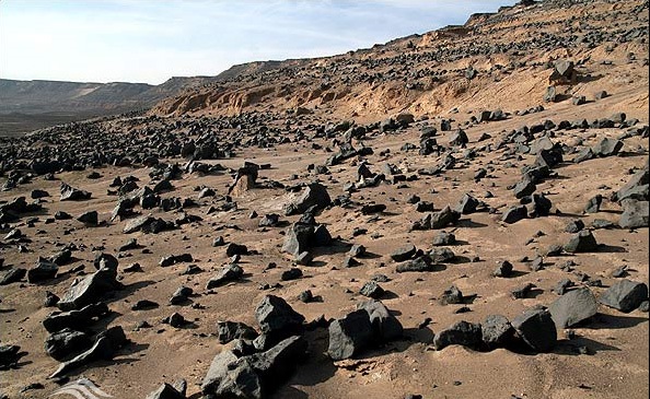
These rocks are exterior igneous rocks. Almost beyond the northern flank of the hill, it is surrounded by an earth wall of varying heights not exceeding 30 m in height, such as a castle. Black lava rocks, some 4 meters high, cover the entire surface of the earth’s walls. The coexistence of basic yellow soil and basaltic black rocks is one of the unique phenomena in this place that has exaggerated the beauty of the wheat region. The altitude of 483 meters above sea level and the unique morphology of the Bryan Wheat Hill distinguishes it from other sandy and lowland areas. If you look at the wheat briquettes through satellite imagery, this hill is like a dipper whose bunch lies to the north. It is worth noting that the northern region of Wheat Barrier is level with the surrounding plains, and only its black soil (the Goddess of Gunpowder), which is like a dipper, causes us to make a mistake and imagine it as flat as a flat wheat hill. The ladle handle is about 10 kilometers long and 3 kilometers wide. The main body of Bryan Wheat is about 15 km long in the northwest southeast jet and about 10 km southwest northeast.
Wheat hill rocks are the origin of the fourth geological volcanic lava flows that have spread over a wide area due to the activity of three volcanic craters. These rocks are alkaline (igneous) and igneous (mineral olivine). As the magma exits the volcanic crater with spindle-shaped motions of lava in the sky, the gases are ejected from the volcano, causing cavities in the rocks and forming special shapes. . The black surface of the granitic hill is covered with volcanic rocks of the fourth geological period.
The three volcanic craters are known as Kordvani volcano, Mahmoudi volcano and Kalut volcano. Naming craters in the name of desert elders has been done in recognition of the unknown desert areas of Iran’s desert. The 3 volcanic craters lie precisely on the Nayband fault. On the eruption of these young volcanoes from the Quaternary period, it can be believed that along the Nayband fault where the conditions of the tidal peripheral fault were created and that the lithosphere thinned out, the lava flows out and over the Lut Plain. And spread over clay layers.
The choice of the name for this region was probably because the caravans between Ghahestan and Shahdad were loaded on the site when the wheat grains on the basaltic rocks were heated after some time. And that’s why the name is called Gandom Beryan
The eastern elevation of this hill is 437 meters above sea level and is at 31 degrees 3 minutes North 59.59 seconds 57 degrees 45 minutes 16/48 East East and at the highest point Northwest of this hill at 31 degrees 6 minutes 51 / 38 seconds north, 57 degrees 35 minutes and 23.56 seconds east is 483 meters above sea level. Gandom Beryan
The hypothesis of the Earth’s thermal polarity in Lut was first put forward in 1952 by Professor Stratel Professor of the University of Vienna in Austria. After aerial surveys, he identified West Nusratabad as the warmest spot on the Rig Yalan. In later years, Theodore Mono confirmed the same location as the Earth’s polarity. Professor Parviz Kadzvani put forward the hypothesis of the thermal polarity of the Wheat Bryan area in Lot. What this hypothesis is based on does not fit into this article, but it is predicted that the hottest point in the central pit of Lut will be based on statistics of ground stations in the areas closest to the Lut Desert. (Statistics of Iran Meteorological Bureau 1355). According to NASA data, the highest ground surface temperature in Lut has been recorded in various parts of the Rig Yellen East of Lut. Not only is Wheat Grill not the hottest spot in Lut, it is 150 kilometers from NASA’s registered points


