Identifying the shape of the Lut area’s rough terrain and the erosion laws that led to the development of the Lut Landscape’s evolution may be the most interesting part of the research program. It has a narrow section and lies to the south of the hills and highlands around Bam and Narmashir as if the waters of the eastern region of Bam are also reached by intersections and central valleys. Along the plains, the elevation of the plains does not exceed 700 to 800 meters and there are two pits in the center of the basin, The web, which is the Ahmed Zang Hole and the waters of the Bam area, is known as the Zang Ahmad Plain around it, and another hole in the north is limited by the extent that the Shur River flows. The position and height of the pits are mixed in all the maps, and that in the center of the Lut on the maps is a large hole called the recorded salt hole in the shape that they gave it. In the maps and geographical notes, it is incorrect. The most geographic point of the army has recorded at least altitude of 270 meters, but we have reached the north even at a distance of 200 meters. We are and it is unlikely that the center of the pit is less than 150 meters high.
Read More ...
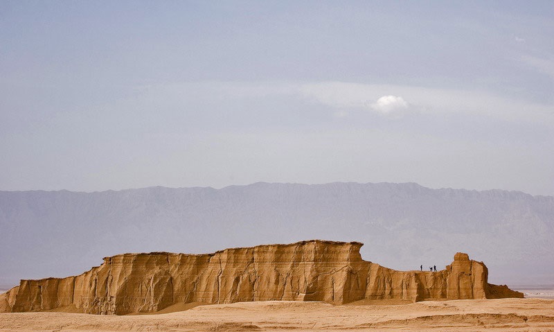
Significant unevenness of the Clutz region in the west and sand dunes in the east and central pits and surrounding plains.
A. Clutz: The Clutz is the most interesting form of roughness in the region. In an area of approximately 180 km and 60-70 km wide, the alignment and lowland filaments continue northwest and southeast.
The height difference between the elevation and the floor is between 20 and 70 meters, and this particular form of ruggedness makes it unthinkable. The question of how Clout emerged like no other in the world is a very interesting scientific debate, perhaps It has a new chapter on the laws of geomorphology. No one has ever fully explored Clutha and there are many legends in the minds of the locals about it. In some parts it is due to the particular shape of the altitudes that result from wind erosion. Scattered columns, foundations, and hills are like ruins from afar Curse Clutte’s urban remains They are believed to have been destroyed and destroyed, and even in the books of the early geographers of Islam, it has been described that there are ruins of cities around Kalut.
In Russian Turkestan there are clayey lands as a result of the continuous wind gusts of low hills and lowlands such as Kalut, which locals call Yardank yardang, and we used to think of aerial photos before local observations that Kalut was a kind of Yardank. Traveling by helicopter to Clutter and checking Clutter’s status at various locations proved to us that Clutter’s building was not easy and that several erosion factors were involved.
In some parts of the clutter, the effect of runoff is high, and it is clear that in some of the pits there is a time of large floods and even the role of water at the foot of the walls, so that further investigation of the operation of the running water in clear clutter should be considered.
Elsewhere, when the floor thickness is high and the salt content of the constituents reaches low, the effect of karst erosion on the surface is evident. Holes and holes and valleys have subsided, and even caves indicate intrusions of water into the ground and Occurrence of karst erosion Perhaps most of the clutter forms are the result of karst erosion.
Wind action in the lowlands should not be overlooked, but the location of the inner sand of the clutter, especially the crescent-shaped sands within the lowlands, and the inconsistency of different winds raise complex issues about wind action. Some of the pits are filled with sand that has been displaced and some of the hills have been submerged beneath the sand masses, in some places the wind is responsible for the emergence of pits and hills. Elsewhere it is due to Klot’s smoothing and fading. These issues need to be studied thoroughly.
There are more ambiguous topics about Clout that warrant further investigation, including:
1. There are small hills in the front and back of the clutter, what we call microclutter or clutter, which may be an example of Yardong.
2. The general direction of the clutter which is northwest to southeast and the complexity of the clutter towards the west in the center of Lut
3. Clutter pits filled with sand dunes in the south.
4. Cluttering and opening of the filaments and laying of internal pits which, in the case of a wide valley and elsewhere in a narrow valley, and sometimes in hills, have a uniform mass without cuts and sometimes a hill. The cuts are cut and scattered.
5. Cloak shape transformations from lost forms to complete and illuminated forms.
6. Finding the Clout Trail in the Plains, and where it used to be in the former Clout and has disappeared today.
7. Cause of formation of clutter in the central region of the Lut Hole.
B: Eastern Sand Hills – In the center of the Low Plains and especially on the eastern margin overlooking the Sistan and Khorasan Mountains there are huge sand dunes which are the most important sandy areas of Iran. And no one has yet passed it. Except for future plans, the camel should be carefully and with complete equipment. The aerial photographs show very complex and entangled shapes in terms of Balakan hills and Saif and Ghor type holes which should be very interesting to look at.
C: The central pits that make up the local base floor, especially the two northern and southern pits, and their relationship with each other and their conditions in relation to the floor structure and the erosion of runoff and karst erosion, and pore-shaped developments may occur. The farms around the plains have an effect.
D: The surrounding plains – on the pedestals and between the cloaks and the foothills and in the central part are broad plains with a gentle slope generally covered by desert formations and over which are coarse and fine alluvial material.
Rivers from the western highlands enter the plain and form alluvial fans at the foot of the mountain. These alluvial cones show intersections with three erosional eruptions that have to be matched with the periods of clutter and water erosion. And at the foot of the footsteps of the old worn out surface, the first erosion of Klot, and the subsequent building surfaces seen in the plain to follow the foothills and illuminated the eroded and eroded eras of Clot to determine whether the famous forms of Clot formerly existed. In the surrounding plains there may have been either disappeared or due to the clutter of the cliffs In the central part of the basin have been found.


LannyJuly 7, 2020
https://waterfallmagazine.com
I got this web site from my friend who shared with
me about this web page and now this time I am browsing this web page and reading very informative content at this place.
my page – behavioral interview questions