Historical geography of southeastern Iran is unknown. In southwestern Iran, archaeological investigations have partially clarified the historical geography of the site, but in Kerman area that has not been archaeologically important, historical geography has also been forgotten if historical geographical studies. It should be preceded by archaeological research because the most important means of locating archaeological suspects is to identify communication routes and population centers along the historical route, and it is to be expected that the historical geography of the Lut region will solve many of the area’s archeological problems.
The Aryan flanks are thought to have been a connection between the Iranian plateau and Sistan, and the ancient Aryan tribes had settled in Sistan and had reached Sistan via the Lut Beckerman roads and the Central Mountains. And in Konkan they are a very ancient people scattered to the south and west.
Read More ...
The natural conditions of the place did not differ from those of today, and to reach the south and west these tribes had to pass through the southern margin of Lut, the Nusrat-Abad road to Fajraj and Bam and its northern trail. These old roads are in limited areas to one side of the mountain. And on the other side is the desert, so by finding ways, the ethnicity of the trace becomes clear.
From the Achaemenid period in Mahan Kerman there is an inscription that it is not known that the child was transferred there and that if traces of Achaemenid civilization are found in the east of Kerman, it should reach Kerman to Fars and Baluchistan.
Works of Sassanid civilization and cities around Kerman and Baluchistan are abundant. Sayat Kerman was founded by Ardashir, the founder of the Sassanid dynasty, and was named Ardeshiri Ardeshir or Ardeshir Furnace, which later became Gavashir, and in the Bam region the effects of Parthian and Sassanid times must be high. But since the geography of the pre-Islamic period is poorly understood, one must look for the past through the writings of Muslim geographers.
Geographers in general have detailed the situation of the cities around Lut and have described the south-south communication routes around Lut, with the cities being mentioned more or less in today’s geographical names with changes. One of the most interesting studies is the naming of cities in the region. For example, the name Khabis itself is not known at all.
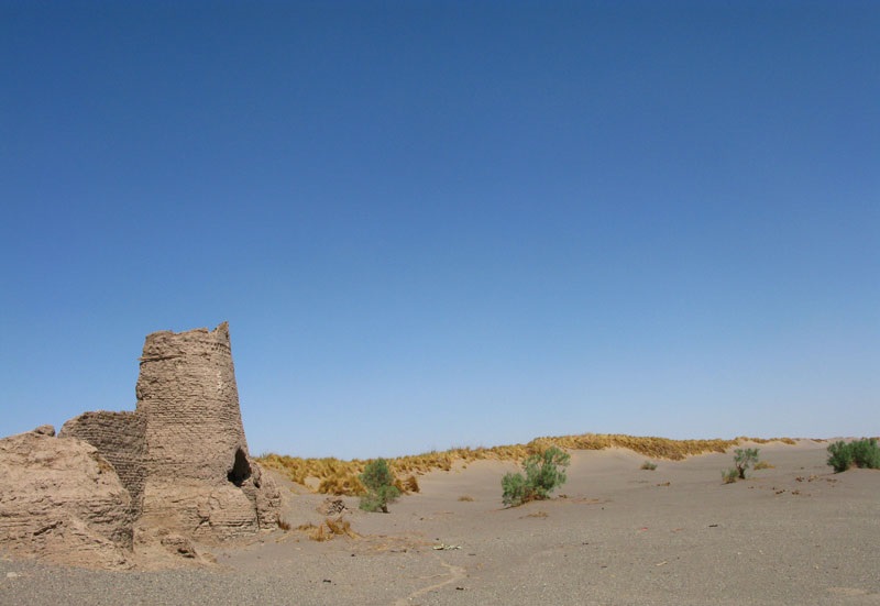
Maqdisi describes the abodes around Naksh and Keshit and Guk and Kathrava in the same description. Kashkit and Guk are the same name today. Nesak must be a fleece but the original name of a large one named Andohjerd is located south of Shahdad today. And where did the name endo round or endoherd come from?
Nomenclature studies of historical sites should be pursued and the correct and original name of many settlements around Lot to be identified so that geographical names may not be recorded or mistakenly replaced with their old names, such as Nusrat Abad, where the ancient and historical names of Spi or Sepi. Until recently, Sebich was illegally recording in modern times due to the reputation of the local ruler of Nusratabad.
Geographical studies of historic cities can reveal the location of some of the most famous and destroyed cities, which are located along prominent historical routes, and the distance between cities is carefully recorded and the location of these cities can be traced back and forth. Finding cities and possibly excavating sites for archeology, such as the old town of Narmashir, attributed to the Sassanid Bardashir, from which today the Narmashir River and the Narmashir Block stand and say the place
Those ten ruins are Choghokabad or Yadigi Nasa, where it is unclear, but there are traces of the old creek.
In the case of some of the historical cities in the geographers’ books, a comprehensive description of the city and its gates or its old fence or mosques has been recorded. And he found the old fence and got a map of the old historic city. The study will be accompanied by a proper map of the historical archive for the city and its monuments will be preserved in Atieh. Old fences around the city. Most of these fences are destroyed and destroyed and in new renovations no matter the historical significance of these castles They have wiped out, for example, the famous Bam Castle, which is of great historical importance, and its original condition is accurately described as being ruined today. Etc … These castles are an interesting place for archeological excavations
In the nearer seventeenth century, travelers or tourists from around the Lutheran countryside visited us, exploring other monuments that were to be seized and found, such as Percy Sykes in his visit to Khabib, a tombstone. It has a history of 173 as well as the remains of a building that was considered to be a church or a place of worship for non-Muslims. These relics are to be found today and are historically significant. Percy Sykes was also known as Bam Castle at the time. Has described itself.
In the old world, there were not many lines of communication around Lut because it was not a suitable residential area, however, choosing the easternmost routes to the north and south, and from Karsan to Kerman and Baluchistan or Sistan Bakraman. And Balochistan and Khorasan have come.
Roads in these areas have not been difficult to find, and over the years they have found suitable paddocks around Lut to penetrate the plateau over long periods of time after encountering salty bogs and dunes and high mountains. The pre-Islamic period is not known, but it is clear that the aforementioned natural passages have gradually become associated with the development of central power and the emergence of domestic commerce. If the Parthian traces are found in Kerman then one must link the roads around Lut Kerman. And if cities were built in Kerman during the Sassanid era, before the creation of the city, the area’s connection with the surrounding area was assured.
The geographers of the early days of Islam have described some of the most famous roads around Lut, although these roads did not exist in the Islamic period, and the Arabs of that time had neither disciplined business nor the way of life.
They had brought with them the construction and it was found that the recorded roads were the same pre-Islamic ways as during which Pahlavi and Persian names were used and by accident these roads are still more or less used.
Ibn Khardazbeh in the early third century AH described the Fahraj to Nosrat Abadra communication route, which is almost a highway between Kerman and Zahedan. No, but there is a minaret to identify the path (the wolf is called the river and there is a road to Shoosheh), and from the wolf to the Bazaar Minar (the ruins are there) and from there to Sabij (Sabij Nosrat Abad is present). There are bars that were on the way to Sistan to Bam, and some have been called Seljuks since before, and certainly the guide bar for the L is from Islam.


