Lot Kut is located in Kerman N2947 to N3050 and E5746 to E5843. In the west of Lut desert, 25 kilometers from the city of Shahdad, there is a unique area known as Kalut (root of the word Baluchi). The long, steep hills of the cloaks and the valleys between them show the power and awe of the area. When the wind is able to create such a shape in a 250 km arena, how much human resistance will it be! Cloister is one of the miraculous landscapes of creation that is spread across the continents and parallel to the northwest to southeast. The length of these natural complications is about 250 kilometers and its width is about 70 kilometers. Klut is the most mysterious and unknown natural occurrence in the whole of the Lut and Iranian desert. In the historical version no one has passed through it and all that has been written about it is in the marginal area and it is still unknown to us. This is due to two unknown complications in west and east Lut.
Read More ...
The cloaks in the west and the great Lut province in the east were the two factors limiting the connection between the western and eastern regions of Lut, and no traveler traveled from the west to the east of Lut. The only route through the Lot Plain was a new route between these two natural disasters and through the Lot Hamad where there were virtually no obstacles to travel except for a few small pits and ground failure. In recent years, the Green Fars Group, led by Mr. Bahman Izadi, has been able to cross north to south. It is noteworthy that no crossings from East to West or vice versa have been reported so far in the Clutha area.
Cleothe’s cashier
Cloud is a combination of the word whole and Lut meaning the city of Lut. Apart from the distinct landscapes in the west of Lot called Clut, they tell of all the ridges and ridges of the western parts of Lut Clut. The word has different meanings in Khorasan, central Iran and the Caspian Sea. In Khorasan, Sistan and Baluchistan, the roots of Kalateh and Kalateh are derived from the castle and fort, which means a village or village that is located high and overlooks the surrounding area. The term “chalate” means small chalate and is generally used in the name of the owner of chalate. In central Iran, Kalat is a rural enclosure and used in the desert plain and loot desert synonymous with a tree or a dandelion. Off the coast of the Caspian it is generally used and in Gilan Calais it means shrub
Reasons for the emergence of Klut
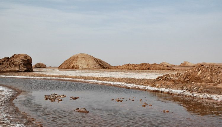
They have measured the thickness of the sedimentary layers of Klot by geophysical methods at about 700 meters. These sediments are mainly composed of non-circular sand, gypsum and salt grains, indicating deposition in a shallow environment by the presence of saline waters that have dried over time. Erosion in the area is mainly caused by wind, water, earth’s gravitational force and temperature changes, the effects of which are the first two factors. The eroded cloaks reach an average height of about 10 meters and sometimes up to 50 meters. Their width varies from 1 meter to several 10 meters. Their wall at the top of the demolition is mildly inclined, which then becomes vertical. The northern walls of the cloaks are upright and on the southern walls a spindle-like haze is visible asymmetric to the northern wall.
The altitude difference between the Clutton Heights and our lowlands varies between 20 and 70 meters, making this passage inaccessible. Various erosion factors have contributed to the emergence of the clutter. In some parts of the clutter the effect of runoff is high, and it is clear that in some of the pits there is a time when large floods occur and even the role of water in some walls is visible. Elsewhere, when the thickness of the floors is high and the salt content of the compounds reaches a high density, the effect of increasing karst on the surface is evident. Perhaps the greatest effect of erosion on the clutter is due to karst erosion. Wind factors are another factor in erosion and clutter. The presence of sandbars in the lowlands and the inconsistency of different winds raise complex issues about the role of wind. Some of the pits are filled with sand that has been displaced by the wind and some are completely buried under the sands. This means that the wind has in some places deepened the pits, and in some cases has made the clutter smooth and fading.
There are various theories regarding the cause of the clots. One of these theories considers the origin of the Clutes to be a common erosion of water and wind created by fissures created in mid-Cenozoic fine sediments. These phenomena occur in the center or bottom basins of the inner pits of the Iranian plateau. Many of these basins form craters or lakes at their lowest point. At the center of these parts are dense, compact soft mud, which is the result of clays and silt transported by water and wind in the recent dry season. At these levels, vegetation of the shrub is scattered and bare ground between them. Hence, the erosion of the excavation in the non-vegetated areas gradually creates fissures along the wind direction and the bushes become stacked. It remains a prominent one in Turkey and in the world term it is called “Yardang” and in Iran “Klotek”. The direction of this clutter often corresponds to the direction of the prevailing winds in the region.
What is apparent in all the comments is the presence of two factors, wind and salt water. Other considerations include the presence of salt in the cloaks and the abundant salt deposits that spread throughout the region. The presence of moist layers in the bottom of the Salt River Hole, the only permanent river in the west of Lut and north of the Cloisters, has played a key role in the formation of various cloaks. In fact, cloud forms are a function of the constant wind in the area and the humidity of the saline river. This type of erosion, called hydroquinone, coagulates clayey clay particles and facilitates their movement and separation by wind. Acknowledging that the Quaternary geological period of Lut had a humid climate, erosion was more rapid during this period and much of the erosion occurred during that time.
Above sea level
On the eastern margin of the cloaks, an average elevation of about 300 meters above sea level is visible. This altitude has decreased by moving south so that it reaches about 240 meters in the vicinity of the Hamoun Salt Lake in Zangi Ahmad. Moving north, this altitude decreases to 210 m in the saltwater pits to the north. Based on the above figures, it can be concluded that the flood head is south to the north and the saltwater is to the north. The lowest altitude in the Iranian plateau is measured in the eastern part of the cloaks in the vicinity of Hamada Lot and within the cloaks with a height of 110 meters by Mr. Mehrdad Qazvinian.
To the north of the Clutz region, at the end of the Salt River, is the erosion of small hills known as the Clutzs (Mini Yardang). The soil of this region is mainly humid with high salinity and salinity that the clays have created convex shapes. Among these clayey clay surfaces are visible from each other. With erections to the south, erosion is better regulated and clutes can be seen as parallel walls. In the north of the Shur River erosion is also very severe, but the shapes created by the southern regions are distinct. In the northern part of the Shur River, the erect walls are formed on hills and the type of erosion is very complex. The forms are dome or rectangular buildings, large castles, short and long walls and human statues. This area is known as the city of Lut in the version of historians. The shape of the erosion and the slope of the slopes depend on the sex of the constituents of the hills. If the hills have marl and clayey salt, the walls are upright and if they are sandy, they have a slight incline.
Vegetation of cloves
From the Sirch Mountains to the cloaks, plant life is reduced. Along the mosquitoes, the gazelle is scattered. On the margins of the cloaks are the bushes of sandy bushes called Nebecas. This area is at the bottom of the vegetation boundary, and within the grooves that enter the clutter are scattered bushes of estragal that disappear as they advance into the clutter. From the foot of the Clutter Desert to the east, inside the Clutter Pit and on the Clutter, no plant life is visible. The absence of vegetative life in Clutha cannot be attributed to the soil and solutes contained therein. Because the clay soil is made of clay, sand and salt. The genus of soil is not significantly different from that of the Clutha margins. Of course, soil salinity is higher in the clutes, but this salinity cannot inhibit the growth of halophyte plants, and in the southern areas of Clot in the Ahmad Lutzangi desert soils that the salinity of the soil is much higher than that of the cloaks. Water scarcity cannot be the cause of the lack of vegetation in the area, as the climates are flowing apart from the annual rainfall of the surrounding mountains. The lack of vegetation in an area as large as this can only be caused by heavy winds in the area, which occasionally blow up and create corridors that help the wind speed. These winds remove any plant roots from the ground and allow the plant to grow.


