Lut desert is located in southeastern Iran and covers about 80,000 square kilometers. From the north to the Shah Mountain, the southern highs of Khusuf (south of Birjand) and Nai Band, from the west to the Kerman Mountains and from the south to the Bam-Zahedan road and from the east to the mountains of Sistan and Baluchistan.
Unevenness and other natural side effects:
In addition to the elevations on the outskirts of Lut, there are also monotonous mountains with remarkable elevation. The highest mountains in the area are Kerman Mountain, which is about 4,000 meters above sea level. The height of the inland mountains is from 1270 to 1730 meters. Because of the aforementioned mountains around, as well as the monotony in the margins of the Lut region, the area under consideration as Lut is composed of two distinct regions of roughness. One is a vast and relatively flat central area that is mostly plain and the other is a solitary footprint and elevation on the outskirts of Lut. Since the maximum elevation is in the vicinity of the pike, so the slope of the land is around the plain to the center of the pike. And since the height of the earth is not the same near the pike, everywhere, Lut has become an asymmetric hole.
Read More ...
The Lowland Plain can be divided into three parts in terms of the roughness and geographical distribution:
1) North Lut:
The northern part of Lut is a relatively high elevation plain with an average elevation of about 1000 meters (between Shour and Basiran) in the northern part and more than 500 meters in the southern part. Irregular cuts form the edge of the plain overlooking the Birjand Salt River Hole. The vast area of the northern lute is covered by scattered sedimentary and volcanic mountains and hills. The sand masses in this area are scattered and low, often between 20 and 40 cm in height.
2) Central Loot:
The central part of Lut is the widest and also the plain of Lut. The southern boundary of the central Lut is a line that connects the township of the west of Lut with the wolf settlement of the east of Lut. The central lute is the most distinctive geographical unit in which complete examples of different types of desert effects can be found, including:
– Highly elevated Plains Pikeh on the eastern and western margins that are relatively rich in vegetation.
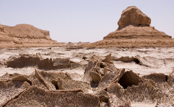
– kalut on the eastern margin: There are some rough clusters called Kalut, 40 km east and northeast of Shahdad. These cloaks are deep longitudinal grooves that enclose a section of northeast-southeast margin of the Lut Plain at an average width of 80 km and an average length of 145 km, in the form of roughly parallel corrugated ridges.
The cause of this natural complication, which is unparalleled in its appearance in the world, has been the cause of severe water erosion and severe wind erosion. The lowest point of the Lut Plain is located in the east of the salt mines, at an altitude of 187 meters above sea level.
– The sand dunes and massifs of the central Lut East, which can even be called the sandy mountains, have a north-south direction and cover a considerable level of lute with an average width of 52 km and an average length of 162.5 km. Most of these eastern Lut sandstones, which the inhabitants of Lut’s margins call sand, are vegetated, with the western part completely devoid of vegetation.
The central sandy and sandy lowlands (hamads) that are located between the sandy masses, in the east, and in the cliffs of the western Lut Desert. Its southern boundary forms the end of the salt-cheetah. Continuing south of the plains and the lower basin of the Sham Chez Hamoon, the plain is covered with parallel sandstones. In this relatively flat central plain, there is only one well-known complication, the volcanic heights of King Mohammed. Plain elevation is 446 meters south of Malik Mohammed Mountain and 270 meters to the north of Shur Gaz Hamoon, which is 270 meters further south than Malik Mohammed Mountain. Most of the plain does not have large plant-wide levels.
– The bottom and desert pits of the salt marshes and rivers of the Lut Plain basin, rarely found on the surface of the plant.
3) South Lut:
The southern part of Lut, also called Lut Zangi Ahmed, is a vast plain whose northern boundary is a line that connects Kirk’s settlement in the east of Lut to the township of Maghreb and the southern boundary of the Azar Heights between northern Bam. And Bam Highway – Zahedan. This section of Lot consists of flat plains and only a few pits or ditches can be found just northeast of the village or oasis of Shahrokh Abad, which is approximately 40 km north of Fahraj. A lot of south-southeast and south-eastern lutes enter this part of Lot (Lot Zangi Ahmad).
Vegetation in South Lut is quite catchy: If we ignore the eastern and western margins of the central Lut, the Southern Lot is the most vegetated part of the Lut hole, and vegetation is more concentrated in the north, central and western parts of the Southwest. But its southeastern and southern parts are poor in vegetation and even in large areas with no vegetation. In this part of the south-east and south-east of Hamada, almost every plant is found in its mosaics. Situated south of South Lut, the Bam and Narmashir Plains form part of the Lut Hole. This plain from the south is confined to the igneous heights of Jabal Barz, Shahzavaran and Bazman. The surface of the plain is covered with flowing sand and scattered sand dunes. This part of the Lot Pit, which is one of the most important agricultural and residential areas of the Lot Ashi in terms of vegetation, especially forest trees, is superior to other parts of Lot Pit.


