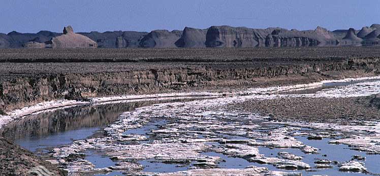
The river, which originates outside the province, originates from the heights of “Khusuf” and southern Khorasan and flows into the province of Kerman from the northern part. The main source of this river is from the northwest and west in the mountains facing northeast of Ravar, a mountain at a height of 2 meters above sea level, with GPS coordinates 2.3 km northeast 2.3 miles to the northeast marshes of Clutte. . Along the route, with the addition of outflow water from the Rover Heights, it covers a distance of about 200 kilometers to the northern end of the clutter, ending in salt marshes or salt pits in the northern part. Tourists who follow the path of Shahdad to Nehbandan arrive at the salty hole after watching the wonders of the cliffs and the beauty of the egg hills. The passage of the Salt River can be seen in different parts of the area and crosses the road below.
In late fall and winter, the salty pits fill the river, and the image of the egg-shaped hills and single-claws, like small islands in the middle of the water, gives a special glow. The salt concentration of the river, especially in low water years, is such that the crystals of salt are always formed in the form of glass panels along the river, and sometimes the movement of water between the salt crystals is difficult. Tasting the water for a few days will leave a bitter and luscious effect on the lips.


Edukacja SerwisyJuly 27, 2021
Thank you pertaining to taking turns the following superb subject matter on your web-site. I noticed it on the internet. I am going to check to come back if you publish additional aricles.
http://www.xmc.pl