Lut Desert is a boundary between South Khorasan, Sistan and Baluchestan and Kerman provinces, with its northern boundary at 32 degrees and the southern limit at 28 degrees. The extent of the Lut Basin Basin is about 175,000 square kilometers, about one-tenth of the total area of the country. Its length is about 900 km from north to south and about 300 km from west to east.
The area is divided into three parts: North Lot, Central Lot and South Lot. The southern boundary of the northern Lut forms irregular cuts on the edge of the plain overlooking the Birjand Salt River Hole. It is a relatively high and wide plain consisting of sand, sand.
Read More ...
The widest and lowest part of the lute pit is the central lute, with the lowest point being 190 meters above sea level.
The unique geomorphological phenomena that have been occurring in the Louth Desert for thousands of years have made this region as a unique region in the world in terms of geomorphological features from more than half a century ago, to many scientists and tourists. Kill.
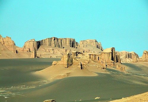
The legendary city of Cloisters, the world’s tallest sand pyramids, 40 Quaternary volcanic cones, vast sand-and-sand zones with a light gray-black-brown spectrum such as Goddard Gunpowder, basaltic lava flows such as the Greatest Wheat, Narrow Waves. , The highest peaks, the Pastry Desert (the surface of these lands seem to be soaked after heavy rainfall and some camels have walked on it) and the Hamada (sandy plains) and the salt marsh are spectacular wonders of the Low Plains.
In the eastern parts of central Lut, sand dunes are located, covering a considerable area 50 km wide and 100 km long. The sand dunes reach up to 500 meters in height (Ahmadi, 1998). Sand fluctuations can be seen in the form of Barkhan, Saif and long hills.
The cloaks are the most typical example of aquatic-wind erosion in the desert and are in the form of single hills or parallel strands located in the western part of central Lut, 43 kilometers from Shahdad. Its average length is 150 kilometers and its average width is 70 kilometers and are located in the northwest-southeast direction. The maximum height of the hills also reaches 80 meters. The Kalutas, also called Yardang, are a Turkmen word.
On the road to Shahdad to the cloaks, about 20 kilometers from Shahdad, the trees and shrubs in the sand dunes stabilized by the plant have created natural desert pots, which are said to be unique in the world.
The city of dwarfs in the southeastern region of Shahdad relates to traces of human habitation around 3,000 BC. The name of the dwarf city is due to the low height of the houses that have been excavated during past excavations. Due to the warm weather, the inhabitants of that time considered the height of the houses low and part of the building under the ground, later due to erosion and other factors part of the height has become less known until today.
Camp Shahdad is the only desert camp in Lut, 20 km from the legendary town of Cloisters. This camp with 40 people is located on the western margin of the Lut Desert at 30/34 North and 57/51 East. The camp was founded three years ago by the Tourism Organization.
The camp has cement-covered pavilions, walls and a wooden roof and is equipped with amenities such as electricity and toiletries.
If you are planning on traveling to Lut, remember that the best time to visit Lut is in the late fall.


