After breakfast in Mahan, we immediately went to Shahdad. Shahdad is known as the Desert Star of Lut, a city of 8,000 people whose starry skies have earned it a reputation for being among the desert cities.
Martyrs of this long-standing history are located on the eastern slopes of the North-South Mountains, between the Lut and Kerman Plains. Shahdad is one of the most extensive parts of Kerman. From north to Khorasan province, south to Golbaf section, east to Sistan and Baluchistan province and west to central part of Kerman.
The Shahdad part of the northwest and southwest is confined to the mountainous areas to the southwest of the Kandaran Mountains and the Shahdad Mountains and to the northwestern desert desert.
Read More ...
From Mahan 7 km to Kerman and then eastward along a 80 km long road will lead you to Shahdad. Along this beautiful and mysterious route you will see massive changes in weather conditions. In the highlands, the cool mountainous climate in the valleys is cool and lush, and in the lowlands of the desert it has a great variety. In the middle of the road we reached the village of Sirch. This village is one of the functions of Shahdad and is known as the paradise of Shahdad. A village that stretches along the banks of a flooded river at the bottom of a lush valley. The village provides all the produce of the Martyrs and their surrounding villages, and this can be easily observed from the blossoms on the trees. From warm dates to juicy peaches and sweet oranges.
The main reason for this village’s reputation is the presence of a large and old cedar tree that is one of the seven sacred Zoroastrian trees. It is said that this tree is 7,000 years old, which I think is exaggerated and it is about 300 years old !!! Part of the trunk of this tree is buried beneath the soil, and you will only see two branches of the tree as if two trees were growing together. This tree is on the bank of the river and is surrounded by fruit orchards. The presence of garbage from chips and puffs and canned empty cans is a sign of the influx of freaky urban visitors !!! He would.
The perennial vegetation of this tree in autumn and winter, when other trees turn to other colors, gives this ancient tree a special appearance. In this beautiful village there are villa houses with an architecture disproportionate to the rural texture, indicating the presence of affluent townsmen for leisure.
After crossing Sirch, we climbed the last mountain and then reached the slopes overlooking the Lut Desert. The water channel on the right side of the road indicates the government’s interest in attracting tourists and developing the area. After about 30 km we reach Shahdad. There is no precise information on the starting point of Shahdad’s history. We all know that this age goes back to prehistoric times. It has been a place of residence and residence for more than 4,500 years. In historical books such as Tabari, Akd al-Ali and Kerman’s history, wherever one speaks of Kerman, the name Khabis (Shahdad) appears. Shahdad has been well positioned in the great roads of history and has been the gateway between Sistan and Baluchistan to Kerman and Khorasan.
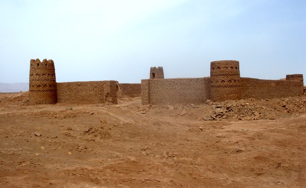
At the entrance of the Shahdad, the Cultural Heritage Organization’s guide to the sights of the place provided explanations, including a recently discovered door and an expression dating back ten years. In addition to the architectural and decorative tiles of some of the 7th century AH buildings, including Imamzadeh Mohammed bin Zayed, Pir Baba the Traveler’s Tomb, Aghos or Bells, Remak Castle (Sassanid period) Choghuki Castle, Stone Castle, Taro Castle , Niu Castle, Water Warehouses and Stone Mill.
The 2-kilometer-long desert camp trail to Shahdad is headed east. Along this path, vegetation and climate change dramatically. The earth becomes a desert state, attracting only the bushes of shrubs and arches at the foot of the hills formed by the roots of the shrubs (nebka or nebuk). One of the interesting points of the gazelle shrubs was more than 5 meters high, and even sometimes as high as 15 meters, according to locals, which is unique in its kind in the world. After another 20 kilometers we reach another intersection, which is marked by a small signpost. After about 10 km, the first interceptor is seen in the field.
The camp is made of about 30 beams with wooden beams and date fibers, some of which are cement-based and the rest are earth-based. Most dampers are powered by a stand-alone switch and the enclosure is beautifully enclosed by chains. Campground lighting is desirable and the only toilet is within walking distance of even the closest campers. The toilets are not very desirable and can provide more satisfaction with a little partial care. It should be noted that the cellphone signal is not received at the camp and can only be contacted wirelessly by law enforcement and the nearest village of Deh Saif.
The camp has been in operation for three years, but has been welcoming guests to Norouz this year through their promotional campaigns. And the asphalt track was created about 6 months ago. Mr. Gholamreza Mehdi Abadi is in charge of the camp which used to be a tourist organization in the city of Kerman, but has been given the responsibility because of the need for a local person to know and tolerate the harsh climatic conditions. Their good cooperation with the guests is very appreciated and their tips and experiences in desert tourism can be enjoyed.
After the unloading of supplies, the excitement of the curiosity prompted us to move immediately to the Clout area. We headed north this time, and after 20 kilometers along the asphalt road, the first signs of clutter, such as a clayey urban ghost, appeared from afar. It was now possible to find out why the city was named Ghost Town because of the mystery of the area. Cloaks are referred to as sharp clay clogs that have been created by soil and wind for centuries. They sometimes reach up to 30 meters in height, like skyscrapers in the city. They cover part of the western margin of the Lut Plain at an average width of 80 km and a length of 145 km. There are no plants in almost all of this vast area. The name Klot is used by the Cultural Heritage and Tourism Organization to refer to these hills and has no specific meaning. Clutter consists of the words Desert and Lut. The cloaks stretch northwest to southeast. These natural side effects are unique in the world.
For lunch, we drove up the hill on the left side of the road, where no passenger cars were able to climb due to the sand, and we had to climb the hill with only an SUV and a pedestrian. At the top of the hill is a large pit known as the Bryan Wheat, which is said to be warm enough in summer to roast the wheat. It is one of the hottest places on earth, with temperatures in the shade reaching 60 degrees Celsius. Due to the cloudy weather during our trip, we had no problem with the heat, but the warm sands in early April cloudy weather could provide a good visualization of the warmth of the sunny days in the area.
Now the band began to freely circulate and photograph the beauties of the area, free of any restrictions. The artistic gestures on the desert sands were the subject of most cameras. Some of them, along with Mohsen, were traveling in the car and discovering the surroundings. Alireza and I also prepared a barbecue for lunch. Kerman lamb that was processed in Mahan and brought to the ice in cold ice promised the delicacies.
After lunch for some rest we climbed up a hill to look at the plain from a higher altitude. Because of the sheer size of the scene and the extraordinary architecture of the Cloisters, I was unable to choose a subject for photography. So I took the opportunity and just watched the beautiful desert scenery. Before sunset we returned to camp with Mohsen and Camp Manager Mr. Mehdi Abadi to buy some supplies to Shahdad and then to another village (Abdolreza) with Sirch village. Along the way we heard some interesting explanations from our companions about the region and the government’s tourism policies. The open-mindedness of the region’s tourism situation and their solutions and suggestions went beyond our expectations. This reflects the strong culture of tourist acceptance in the region and will certainly further enhance their land in the future. The occupation of this sector is agriculture (horticulture, dates, barley, garlic, etc.), sales (in Shahdad the number of food stores is clearly differentiated by population) and smuggling. The reason for this is the lack of a suitable job, so young people go to school after graduation. Of course, the smuggling is almost semi-official, with most of the gasoline and diesel fuel being shipped to border towns and sent to Afghanistan through professional smugglers. We have arranged for Mehdi Abadi to help guide us into the desert visit tomorrow morning.
It was very dark when we returned to camp, and our companions were very worried. It seems to us that we decided to sleep in the tent instead of camping in the campgrounds because it would have been impossible to predict a comfortable morning fly. We immediately raised our tents and then roasted the sausage and potatoes alongside the fire that Mehdi Abadi had made. In this regard, we felt the presence of two jackals around us. Mehdi Ebadi had previously told us about the hype he was seeing at night, but the existence of the two jackals was unexpected. After dinner with Mohsen in the darkness of the night, we drove the car to the black desert desert on unpaved trails and walked around the camp for about an hour. The camp is surrounded by not-so-high hills on three sides.
One of the interesting things about the deserts of these areas is the existence of very diverse animals such as mice, rabbits, foxes, wolves, deer and even boars that mainly live in the forest and marsh. This may be due to the presence of oases, water reservoirs and lush villages on the edge of the desert.
Clouds that had covered the sky the night before made it impossible to see and observe the stars. On regular nights every night for about half an hour, or at the request of even more guests, the camp dips into absolute silence to find more glittering sky lights. So there was no choice but to sleep. I would rather sleep in the sleeping bag outside the tent. In the morning a heavy wind began to form, which made the sounds of the tents clash. I woke up at 4.5 and watched the environment. I was going to go to Shahdad for shopping but it was still too early. At 6 o’clock the rest of the group also woke up. Along with Alireza, we went shopping. In Shahdad, there was no shop except a shop selling bridal and wedding accessories! After touring the city and refueling, we eventually found a bakery and shortly after buying groceries and returned to camp. Everyone was awake, and after breakfast we quickly made our way to the Low Plains with Mehdi Abadi (guide).
His comments were transmitted to others in any area by wireless. We first visited the inn that had a large storage room (rare warehouse water). The four inns of the inn, like the restroom and the large dry storage room that are now dry, form a one-way structure to store water on one of the square sides. The existence of numerous caravansaries in these areas was due to the strategic importance of the area on the Silk Road route. This area was a bridge between Sistan and Baluchestan, Kerman and Khorasan and many travelers had to stay in the desert and relieve thirst and fatigue.
A little further away is a large plain known as the Five Fingers Rig, where in ancient times a convoy died of thirst and fatigue. There are sharp hills like the finger of the area.
A little further up the hills along one another evokes the image of a camel caravan in mind. There are many like this sand dunes in this area. This is known as the Camel Hill
Next we come to a river called Cal River or Salt River. An acidic salt is recommended to avoid touching the water as it may corrode the skin. The margin of the river is swampy, with salt crystals within it. A river full of water but totally useless. The presence of such intestines in the desert causes salt to circulate on the surface of the desert, making the face of the desert dry. Next, we reach the intersection that leads to Zabul and Zahedan and to Birjand in Khorasan province. It is shorter than the main roads in the province, but is not recommended due to the lack of security due to the presence of crossings without local guidance and coordination with the police.
On our way back we came to a place where no living thing, even bacteria, could survive. Because of this, corpse erosion is also taking place slowly. According to Guide, 40 years ago the camel’s body remained in the area, which was hit and destroyed by tourists last year and now only its bones are kept in camp.
On the way to Shahdad, we visited a beautiful aqueduct at a depth of 15 meters with beautiful canals and chambers that were supposed to be under the presidency of Mr. Marashi (head of the Cultural Heritage Organization) restaurant (Payab). Also the beautiful villages of Chahar-e-Farsokh, Deh-e-Seif and Andohjerd with lush fields and beautiful palm trees around Shahdad can reduce the hot and dry face of the desert.
In the city of Shahdad you can also visit the old mill of Shahdad and the city of dwarfs. The reason for naming the city of dwarfs is because of the low height of the houses that have been excavated during past excavations. Due to the warm weather, the residents at that time considered the height of the houses to be low and part of the building was underground. Later on, due to erosion and other parts of the area, the area has become less popular until today. Other important discoveries of the Shahdad can be traced back to the third millennium BC. Another work is the Pottery Cup, dating to the Achaemenid and Parthian periods. Also in the Shahdad cemetery, there are about 25 statues of men and women made of flowers. All these objects have been transferred to the museums of Tehran and Kerman. After visiting the natural beauties, I no longer had any desire to visit the man-made objects. We would like to take some souvenir hills and shrubs with us.


