Rig Yalan is located in N3057 North to N2921 North and E5905 East to E5955 East in Kerman province, northwest of Sistan and Baluchestan province and south of Khorasan province. The intersection point of the above mentioned province is located in an area near the north of the Rig-Yellen. The rectangle has a rectangular shape and extends north to south. The distance between north and south of Rigsar is about 2 km and its east west is about 2 km. The ridge of hills has a southwest-northeast direction, which in the northern areas, this slope is more to the north and in the eastern areas to the west. It is bounded on the west by the central Lut Hole, on the north by ten Salam on the east to Nosrat Abad, the Spi and Okhuran heights, and on the south and southwest by the Lut Zangi Ahmed and Kal Shur Lut, extending to the Baluch water.
Read More ...
The plain height is about 2 m above the free sea level in the western margin of the Rig-yellan and about 2 m in the eastern margin. The western slope decreases westward to the center of the Lut Hole. In the eastern margin of the Rig Yellan, this slope increases eastward. The humidity in the region is reduced by about 2% in winter and by about 2% in summer. The height of the hills increases from north to center and decreases again from center to south. In the southern part of the Rig Yelan, the hills link to the western cloaks of Lut by shifting southwest and eventually west. This area falls into the Lot division, in the South Lot or Ahmad Zouti district, which is out of the text.
Peak Rig
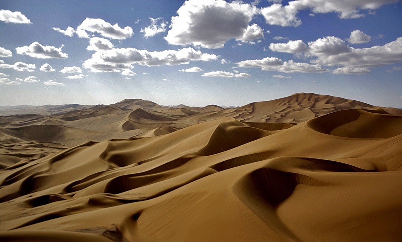
The sand peaks of Rig Peak are located between N3008 to N3044 and E5923 to E5927 between Kerman and Sistan and Baluchestan provinces. The area is part of the sandy sandy communities of Rig Yellen. Due to the high height of these hills and their high elevation compared to other hills in the region and Iran, it has been called the Rig Peak. The highest elevation of these hills in the central part of Rig Yalan, at a height of 2 meters at position N302058 E592852, was measured by the Desert and Desert Deserts Group of Iran. The hills rise from south to center and decrease to the north as they rise to other hills. These sand dunes have a completely north-south direction in spite of the southwest northeast direction of the body of the Rig-Yellan Ridge, dividing the Rig-Yellan Ridge into two eastern and western zones. At the foot of this sandy wall lies a huge sand funnel that has doubled the size of the sand peaks in the area. The formation of this area is volcanic highlands that have been covered by lava sand over time. The two prevailing winds in the region, one from the southwest to the northeast and the other from the southeast to the northwest and the result of these two winds, have created such a huge wall of sand in Ristanistan.
Genesis of Rigestan
The lute pit with its surrounding heights shows the view of a block and a solid mass that orogenic and structural factors have not been able to greatly influence and only the marginal sediments have been severely affected. The orogenic activity in Lut has been associated with the occurrence of thrust faults with abundant fracture and bending. The complex of this process has led to the emergence of the Lut Hole and its collapse to the surrounding heights. But the presence of sedimentary and igneous elevations in Lut and the Rig-Yelan area indicates that Lut’s geology has changed since the third geology. The presence of thick and hard calcareous margins in the Lut and Rig-Yelan margins indicates that the Lut Hole margin is covered by the deep sea. The presence of degraded sediments in Kerman basin confirms that in this basin it is less elevated than surrounding areas such as Lut Pits and Kerman Sea stretched only to the bottom of Lut Pits. In other words, the appearance of bumps and recesses in the first and second geological periods was exactly the opposite of today’s conditions. From the end of the second period, volcanic activity on the margin of the Lut Hole is intensified and Kerman Heights are formed with the onset of Kerman construction activity. At this time, the Kerman Sea water flows around, including the Lut Hole and evaporative shallow sea, which wash the young Kerman and Nosrat Abad heights, leaving large portions of it and submerging fine particles into the surface and basin. It kills a lot. With the continued orogenic activity in Kerman and north of Nosrat Abad, Lut was surrounded by two eastern and western walls, which were the main cause of the Lut climate change and the drying up of the Lut Sea.
These sandy buildings are found in the form of Barkhan, longitudinal and sometimes intermediate hills, and often interconnected. The main cause of these hills are the winds blowing from the southwest of the region. The western and eastern limits of the hills are quite clear. For example, in the east the hills end up in the plains and eastern highlands. The material under the sand dunes is made of intra-Lut sediments, such as degraded and evaporated sediments such as marl, salifers, gypsum and others, examples of which are visible in the valleys between the sand walls. In the southern part of the Rig Yelan, the beginning of the formation of these sandy ridges, the hills are solitary and low-lying and often moving. To the north these hills gradually become complex and inhabit. Raw materials for these sand dunes are provided from remote areas and accumulated in the area. The materials that result from the destruction and erosion of the cloaks in the west appear to be the main constituent of these sand dunes. The huge eroded volume of west Lut must be stacked somewhere. Given the shape of the wind movement in the cloak grooves, which blows from north to south and shifts to the southeast in the face of the Shahdad and Kashkit heights, then diverts a little to the east and then disappears. The southwest wind from Bam moves this sand mass to the northeast and accumulates in the Rig Yellan. Scattered igneous heights beneath the accumulated sands act as a barrier against the wind, causing the sands to accumulate and form a sandstone.
Vegetation
Rig Peak lacks vegetation. The presence of heavy winds in the area that have been blowing for many years, as well as the lack of water resources throughout the area have prevented the plants from growing. Only in sandy ridges at the summit of the sand peak, where plants are somewhat protected from wind and relative humidity in the sand, can the limited growth of the sand-friendly plant community, especially bush bushes and shrubs, be observed. Unlike the central Lut hole, which is completely devoid of vegetation, the situation is different in the Yolan Ridge, and the vegetation is very weak and scattered, though hardly visible. In the northern areas, the cover decreases sharply as it moves toward the center. In the central areas vegetation is visible on the back slope or on the eastern slope, but no slope is visible on the slope facing. This is due to the high moisture content in the southwest winds, which creates vegetation on the eastern side of the hills. In the southern regions and along the Rig-Yellan to the Clutz region, vegetation is much more abundant and diverse
historical background
At the time of the Achaemenids, in the eastern part of Lut, the Ariaspian tribes lived. Ariaspi is an Avestan word meaning skilled rider. This people, now known as the Baluchi people, helped Cyrus greatly in the wars in eastern Iran, and so he was helped. As such they were exempt from taxation and there is no mention of them in the Bistoon inscription as a taxpayer. Arian writes in the History of Iranian Ethnic Relations: This people gained a great deal of respect and respect for Cyrus in the Achaemenid court and had some form of autonomy in their region. After conquering Iran, Alexander the Great honored them and renounced their occupation of their lands. Greek historians have greatly praised the Ariaspi people and have regarded them as an example of full progressive and sacred tribes. Unfortunately, many of the historical names of the Lut suburbs have undergone unnecessary changes and have made it difficult to match the current locations with the historical manuscript. It is therefore appropriate to pursue anthropological studies on historical sites and to identify the correct and original name of many settlements around Lut, so that geographical names will not be recorded or mistakenly replaced with their old names. For example, Nosrat Abad, which had the ancient and historical name of Spi or Sepi, was founded during the Pahlavi era by the reputation of the local ruler of Nusrat Abad. The following is an overview of the historical areas of the Rig-yellan fringe.
Ten Salem
It is not clear exactly where the name of the ten Salem was derived from. It is likely that the name of one of the Khorasani Muslim commanders was Salam Ibn Zayd, who was the ruler of Khorasan during Yazid’s rule. Ten Salem residents know the name from Salem’s brother Iraj and son of Fereydoun. This area is located at the end of the north-south road known as Lut Road. There are currently ten small salmon farms whose people earn more than their palms and livestock. Dates are not high quality and are sold in Nehbandan. The earliest sand dunes of the Rig Yellen are visible 5 kilometers south of Ten Salem and are therefore well positioned to attract tourists. The only artifacts from the boom of the 10th Salem in the past are its numerous aqueducts and a fortress within 3 kilometers of which only one remains.
Nusratabad (Speed or Speed)
Nosrat Abad is located along the E5959 latitude and N2953 latitude with an average elevation of 2 m above sea level, 2 km northwest of Zahedan and on the Zahedan-Bam route. This city is of great importance because of the old times along the route of commercial military convoys that traveled from central Iran to Balochistan, Kandahar and even India and the only settlement between Balochistan and Beck which was a vast desert. . Around the village of Garg in the western Nusratabad area of the nightingale hunting area, Omar Hassarouieh plain is one of the native habitats of birds such as Quebec and animals such as rams, ewes and deer. There are also mammals such as foxes, jackals, hyenas, wolves and others. Much of the city is made up of the Naru tribe, one of the great tribes of Balochistan in the past, which have played a major role in the historical events of this land. About the naming of this tribe, its people believe that they lived in a region called Naru meaning that it didn’t grow. Until the Qajar period, it was known as Speed, Sepit and Sepah, but in the Qajar period a ruler who was sent from Kerman or Bam to the area was named Nusrat al-Dawlah, known as Nusrat Abad since his time.


