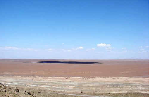
To the northeast of Lake Urmia there is a relatively large desert around which a desert is formed. In the northeast corner (in the distance between Sharaf Khaneh Port in the north, Dashaksen Above in the south) after the lake, there is a vast desert plain stretching eastward to the Tabriz proximity. This desert plain has no specific name. The people of the adjacent desert areas call it salty and swampy. The area of the desert is more than 4,000 square kilometers and nearly 2 square kilometers of it is exposed to the floods of the lake. The long axis of the desert is about 2 km from northeast to southwest. Its average width is 2 kilometers. The absolute height of the desert is 5 m in the eastern corner, and the center of the desert, which is at sea level, is about 2 m lower than the eastern part. The lake is 2 m high. The Kabudan Desert has created the most striking contradiction not only in the Lake Urmia Basin, but in the whole territory of Azerbaijan.
Read More ...
Rivers flowing from the eastern highlands (Sahand Massif) join the Trench River and flow directly into the lake or coastal marshes near Azarshahr. This way the eastern side will not reach any desert surface. The rivers flowing from the north to the south divide into large branches before reaching the desert at the cone surface and allow for irrigation of orchards and arable lands. The water of all the rivers flowing from the north and northeast to the basin contains large amounts of salt. Ajay Tea, the largest river in the basin, by cutting several salt domes in its path, is most effective in forming saline soils and even extreme lake salinity.
On the west side Bonab covers lacustrine sediments, including salt, clay and clay, and due to low permeability of surface water, it has created marsh and saline. One of the relatively flooded rivers is the Urmia Lake catchment. It flows through two rivers in the Bonab Plain and most of the settlements in the area. The surplus of water flows through the village of Qarachiq to Lake Urmia. Due to low permeability, the land of this village cannot transport all the water. As a result, most of its lands have become swampy and swampy. The plain of Maragheh and Bonab plain is about 2 square kilometers, of which about 4 square kilometers is marshy saline lands. The saline lands around Lake Urmia, which is about 2 square kilometers, are of no value in terms of agriculture and water reservoir.
The side of the Wajab Plain is about 2 square kilometers, of which 2 kilometers is a marshy salt marsh. The Malek Kennedy Plain Basin is about 2 square kilometers, with 2 kilometers of swampy saline lands and the rest of usable agricultural land.


