Rigby Jen’s description:
The Rig Jen Desert is one of the most impassable desert regions of Iran and even the world, full of sand dunes and salt marshes. There are currently few signs of life in this area. This desert is located in the southwest and west of Kavir plain, south of Semnan, southeast of Garmsar, east of Kavir Protected Area, north of Anarak and west of Jandagh. There are no springs or wells in the area.
Locals believe the land is cursed. In the old days, caravans and travelers never crossed the desert. The ancients believed that this land was cursed and the base of the devils and evil spirits. The people who live around the desert believe this. Locals say that anyone who entered the land has not survived and disappeared. Rig Jen is also called the Bermuda Triangle of Iran.
Read More ...
Trip Report:
At 14:00 on Thursday, 21 January 91, we boarded the bus at the J Isfahan Terminal and arrived at Anarak at 17:40 after crossing Segzi, Foothills, Todak and Nain. Anarak was a very small town where, according to the driver, out of its 8,000 inhabitants there were now some 2,000 people. We had already coordinated with an Anarak resident driver and after arriving at Anarak we went to Allahabad village. About 70 kilometers to the village of Allahabad we had the road ahead. After seeing the 15km trail to the shepherds, we went another 4km and then turned to the west side of the asphalt road. From there we went about 10 kilometers to reach the deserted village of Allahabad at around 19pm.
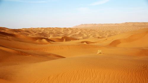
We separated from the driver and told him to wait for us again in the Nakhlak mine for another 48 hours. We were supposed to camp at night on the side of the road and start the morning. But we were surprised, because there was a farm owned by a man born in Anarak named Dr. Jafari where some workers lived in a small room. Their job was animal husbandry and farming. Very kind and friendly people. We were also pleased that tonight there was no need to face the cold weather. There, we met a group of tourists who had two-wheeled cars running a few kilometers inside the desert. After dinner around 9pm, we decided to go to bed and suddenly four more people entered the room. Two Tehrani people, along with two French people, had come to Iran for filming in the desert. They also left at midnight but returned around 3 am. Finally, after a few hours of sleep in the morning, we woke up around 5am and after packing our bags and eating a glass of milk and dates, we left the farm around 6am and headed northwest and then headed north. We went and we walked and we walked. The beginning of the route was smooth with the ground firm. Plenty of shrubs and plants were found. It was not difficult to walk. Below is a picture of the beautiful sunrise in the desert.
After a couple of hours the sand dunes rose. They were not too difficult, but after about 8 km of navigation we started west to reach a desert forest in the heart of Rigg and alternately we headed west. Moving further west and slightly northwest, we had to cross long sand walls. Great sand walls and hills! Walking in them takes a lot of energy. The legs sink to the top of the wrist in the sand. You have to go a long way to break the slope of the hills. In general, we had no worries about working hard because we needed experience and exposure to the tough conditions we were prepared for. We felt we needed to do this in order to get heavier plans in the future !!!! We left until about 11am to reach the desired forest. The image of the forest can be seen below.
It’s 17 kilometers past the start of the scroll. The compaction is very noticeable. Please don’t fire if you come here. You are likely to destroy the whole forest. Eating breakfast until 12pm !!! And we rested. We continued on our way at 12 o’clock. Because we were going to get out of the sand and head towards the seasonal river, we headed north completely, so we went through some tall walls. Because the western walls were east, it took a lot of energy to Finally we reached the plain. We were about 5 kilometers away from the forest but still a few kilometers away from the river. Due to lack of time and the start of the storm, according to the plan supervisor, we continued down the river and headed west but wind. It was very heavy. The wind was very hard to drive. The wind was blowing from west to east at the same time. Char had to continue. With a heavy bag, counterclockwise. This is where Adam tells himself what am I doing here !!! We were left out of the hills and walls, but the wind was bothering us. We walked about 6 kilometers in the most difficult conditions. About 15:30 we headed back to the hills and sandy walls to stay in the hills at night and be safe from the winds. We found around 16:00 for a night stop. We could move for at least two hours more, but the wind was very annoying and wasted a lot of energy. We first lit the fire with the broken down trees in the sand dunes.
We sat around the fire and rested and pitched. To the supervisor’s experience, we spread the coals at night and covered them with soft sand. It was rugged, but in short, we set up the floor heating system under our tents !!! This was the second surprise of my trip. Just be careful if your coals do not cover well with sand, your tent will burn. You see a lot of damage with this dollar !!! We slept for about 8 nights. It was midnight and I woke up. I do not have the habit of sleeping on a rigid place. It was the first time in my life I slept in a tent !!! And of course it was the second time I slept in a sleeping bag. (The first precipitation was in the farm room the night before). I heard voices. Those three had all fallen asleep. There was a purr sound of my friends. The second sound is related to the gentle breeze and the rain on the tent. There was no news of fairies, fairies and ghosts !!! And there is no one to be afraid of. Another living thing that doesn’t last! I said all this to myself and fell asleep again.
Application Navigation Route
Day One Summary:
Departure time: seven hours and forty minutes
Stop time: two hours and twenty minutes
Average speed: 3.7 (three and seven tenths) km / h
Navigation Length: 28.26 (Twenty-eight-sixths) kilometers
Camp height to sea: 830 m
Water consumption: Six liters
Direction: See the relevant GPS file
Day 2: Wake up at 5:45 am Saturday morning. It was very, very cold outside. On the outer cover of the tents, there was a thrush layer. We were touching the bars of the tent. I don’t know how we slept in that cold night. The kind supervisor lit the fire again. We were collecting the equipment for five minutes, warming the fire for 10 minutes. We ate some dates, warmed our bodies, and finally started our journey westward at 8am. Again we went a little further northwest from the sand (sand dunes) to increase our speed and again to the west. This, though slightly longer, would slow us down due to our temporary release. From the hills. At 11am we ate breakfast and continued again. After three hours of traveling more than 10 kilometers again we turned south and entered the sand which was no escape to reach them. From here more than 20 The kilometers had to move to the south and, of course, a little to the southwest. The second day was mild and luckily not windy, so the position was perfect for taking pictures. However, this increased air consumption. Along the way we encountered one of the tallest walls of the route, which was 940 meters above sea level. On top of that we had beautiful views. The mountain at the bottom of the palm mine was also visible.
But there was a long way to go. After a jogging and landing 100 meters from the wall we went and went and went and went. And again we went. We had lunch around 3:30 pm. At about 17:10, mine lights were visible from afar. It was hard to see.
We had another 12 kilometers to go. But fortunately the road was smooth and the bags were almost light. Because 80% of our food and water was consumed. For the last hour, although the road was smooth and smooth, we were very bothered by the rocky road. We left until we reached the mine lights at 8 pm. We got close. It had barbed wire !! We walked around until we reached a mosque. Nakhlak mine mosque. We were drinking water and we were suddenly surprised again !!! We were taken to the entrance guard by a fire truck for illegal entry into the mine. Fortunately they shortened our path. They left us there after much scrutiny and scrutiny (fearing that dynamite would not be removed from the mine). Finally the taxi driver joined us and drove to Isfahan. We arrived at Isfahan at 23:00. We had to turn toward the eastern lights at the entrance to the mine from the distance we saw, but the presence of a car on the west led us.
Day Two Summary:
Departure time: nine hours and twenty minutes
Stop time: three hours
Average speed: 3.8 (three and eight tenths) km / h
Navigation length: 34 (thirty-four) kilometers
Water consumption: Eight liters
The GPS file provides the path to the attachment.
At the end of the support team including Christ Forouzmehr, Javid Kazemzadeh, Ebrahim Moeini and Monireh Dadkhah who were in charge throughout the program as well as thank Mohsen Adib for the pre-program guidance.
Some coordinates:
Subsidiary of Allahabad Village from Main Road:
N33 35 16.6 E54 17 49.8
Mani Night in Allahabad:
N33 37 05.9 E54 09 28.7
Forest:
N33 41 40.7 E54 04 17.8
Manny’s Night In The Rig:
N33 44 15.2 E54 00 18.9
Palm Tree Mine:
N33 33 43.8 E53 50 30.5
Sub-mine of Nakhlak from Main Road:
N33 30 48.8 E53 54 49.9


