Samsour plain is located 120 km south of Zahedan in Sistan and Baluchestan province. This plain is located 45 km from Bazman and is considered as a part of Iranshahr by national divisions. . This plain with an approximate length of 50 km and a width of 15 to 20 km is located north of the fortress of Bazman and east of the Gohar catchment in Sistan and Baluchestan province and the Semsour aquifer is 30 km inland.
Read More ...
The boundary of the plain of Somsor is as follows: North of Zahedan Bam Road and Wolf and Hyderabad Area Northwest of Narmashir and Reagan Region North East of Pirsuran Mountains. Live Mountain: Snowy Mountain) To the southeast of the Potash Mountains (towards Gohar Kuh) and the Sefidabad area. East of the Powell and Millet Tak Mountains to the villages of Qale Bid and Chah Ahmad .. West of Bam Iranshahr Road and along the Jabal Mountains. Jeref and the Deer Valley area. Samsur plain includes Samsur plain which includes (settlements) Sefidabad Shorab (Naru) Sassaur’s victims and sages, Saurig, Powell, Moghak (Raghok), Rikk (Rikok), Boss water, Surdqal (Duck or Dagh) The water flows into the river of Samsor and Reagan), Mishdieh (with a large iron mine), Millet Tac, Naluk (Naluk) Serkal, and Sheikh clan areas, Masjid Abolfazl and Chah Neli villages (Nale means Baluchi). (Massive)
The plain of the Samsur plain is named for the samsur (because of its two flat mountains called “Sam”) and because its rocks are red (red is called Baluchi Sur).
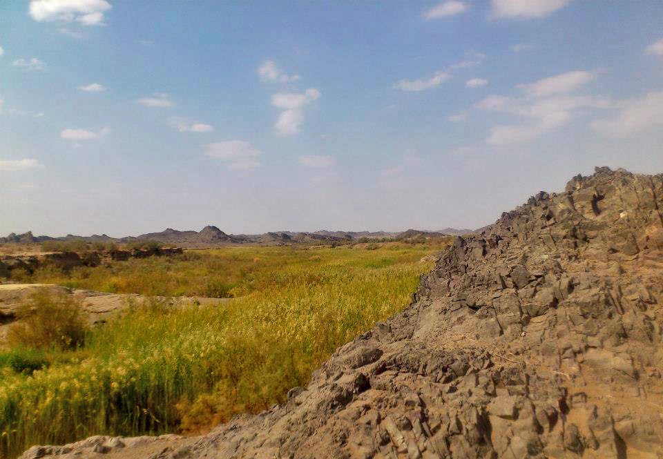
At the center of the plain are some 100-meter-high rock formations that rise to an island from the heart of the plain and are likely to have been caused by volcanic activity in the area. The northeast end of the plain leads to the southern ridges of the Lut Plain, which, in addition to providing an exquisite view of the moa and suitable for the Jabirites in the plain.
In addition, evidence suggests that the meteorite may have collided in the Iranshahr plain 80,000 years ago. The Samsoor area is located near the village of Kheirabad in Iranshahr. This 3 and a half km deep pit is 30 meters from other geological phenomena. Studies have shown that the pit has nothing to do with the volcanic mechanism around it. Bazman volcano is located 50 kilometers south of the pit. The results of field documentation and analysis of sampling are under investigation. The sump pit would be the first of Iran’s meteorite pits and the second in the Middle East after Saudi Arabia, if confirmed.
Other features of this area can be noted that this plain is the location of the wild goddess Ali, especially whole, goat, sheep and goat from the forbidden hunting area to the mountains and hills of Gohar Mountain and Caviar.
This plain is the site of a beautiful and riverside river called the Semsor River, which is a permanent river. The river originates from the 50 m asphalt road of Kheirabad village as a boiling spring from groundwater sources and extends for approximately 40 km downstream of Abbas Abad Naluk village. The riverbank is covered with reed and reed vegetation and has good biodiversity.
Wildlife in the area can be found in Quebec, Thyoh, Baqarah, migratory aquatic birds such as small cormorants, acorns, green-necked ducks, ducks, and hubs. The mammals of the area can be called Jabir, hyena, jackal, sand fox, leopard, moth, rabbit and…. Vegetation of the area includes lynx, hawthorn, terat, gaz, scanbill, redhead, scab, herb and some herbaceous species. The reptiles of this plain can be named Agama and Jacko, Lizard, Skink, Desert, and Snakes. The set of geological and ecological features mentioned can make the region one of the largest tourist areas in the country.
The results and information obtained from the geoelectric studies of the Samsour plain have led to the identification of one of the largest groundwater resources in the plain. Due to geophysical data and altered data, the water quality of the aquifer layer in the eastern and southern parts of the aquifer is of better quality and in the northwestern part of the low resistivity plain of the aquifer the results of these studies indicate that the groundwater quality of this area is low. has it.
Due to the amount of water reservoir in Samsur plain is one of the largest groundwater resources of Sistan and Baluchistan. In addition, the region is rich in minerals. Studies carried out during the Bentonite Comprehensive Exploration Exploration Project resulted in the identification of more than one million tonnes of bentonite. Bentonite is a mixture of clay minerals used in casting industries, iron pellets, oil industry drilling, animal waste collection, the environment and so on.


