The desert is the most famous and yet unknown geographical phenomenon of Iran. It is a geographical desert that is united with the culture and history of this region. Desert is an Iranian life, culture, art, poetry and in a word of identity.
Sightseeing in an area that glances to infinity, being struck by the prospect of flowing sands and burning dunes is one of the motives that have continually led nature lovers on the Iranian desert. A brief glance at the voyages left by these travelers shows that, at every turn, tourists and researchers have tried to experience at least parts of the Iranian desert.
We learn the greatness of loneliness on its nights sitting in the desolate breeze of the desert on the gentle slopes of its hills and sinking into the world of stars. Surprisingly, the first traits to be attributed in the first moments of the desert visit may be the desert star nights that make us feel light even in the dark.
Read More ...
Another time we intended to travel, and another destination is the legendary Desert Rig. The goal is to register a new route in one of Iran’s most impassable desert areas. After a week of reviewing area maps and satellite imagery, the new route boundaries will be clear. Travel time is 4 days, which can be increased to 5 days in case of unexpected and unforeseen event. Departure from Tehran led by Iranian Desert and Desert Group with the cooperation of Iranian Travel Agency started at 3:30 am December 12 with 12 cars and 38 people up to 10 pm the same day at Jandagh gas station as the last point. Civilization on this dangerous path, let’s come together. The trip included 60 liters of gasoline for each car (in addition to the tank stock) and 40 liters of extra water, and the journey to Rig Jen began at 11am.
Cashback
The word jinn means hidden and therefore, after Islam, the angels were called jinns because they were hidden from human eyes and could not be seen. It means concealment and concealment in all derivatives of the word jinn, such as the heart and soul of “janan” because they are hidden and hidden. The paradise is called “Janet” because it is hidden from our eyes and is called “shield” because one is hiding behind it during the war. The “fetus” is called the baby in the womb, because the baby is secretive in the womb, and also called the “elf” because it is hidden from our eyes.
Lack of water resources in the vast expanse of sand jungle, along with natural barriers such as salt marshes and high sand dunes, were factors that kept this area out of human reach for centuries. These same factors have made this vast arena humanly concealed throughout history and hence the name Jen. Folk and legendary folk tales and stories about Rig Jen have generally come from the inability of the suburbs or passengers to cross the line. There is a great deal of heat in this area, given that the genus of the genus is heat and fire in the Qur’an probably not influenced in choosing this name. Also covered by the southern portions of the sand jungle with the sand dunes and the sound of the wind moving through these hills are definitely factors influencing public belief in the existence of metaphysical powers in the area. The large difference in night and day temperatures and the crushing of the rocks due to this gross dispute known as “crying stone” were also attributed to the same metaphysical factors.
Geographic Area
There is no clear boundary for the Rig Jen. Summary This area is located in the central geographical area of central Iran in the western part of the Central Desert or the desert plain and to the north of Semnan Military Road to Teachers, Sulfur Mountains, Garmsar County, West to Desert National Park, Nakhjir Heights, Taleh Mountain On the east, the Devil Mountain, the Tail Mountain, and the Tang of Darkness, are bounded on the east by the Jundak to the teachers, and on the south by the Anaraks, by the shepherds and Mount Mahalladi (Great Mountain). The Jinn extends from northwest to southeast and covers an area of about 90,000 square kilometers.
Geological structure
Sand elephant sandbags
The word ‘sand’ gives the impression that the area is completely covered by sandy so-called local sand, while much of the sand is covered by salt marshes and flat sand dunes. Huge clumps of active and unconventional sand dunes that cover a large area are called Erg, which in Arabic is called “sweat” and is known in Persian as “sandstone” or “sand”. . The Rig Jen is a eroded plain that now occupies the sand dunes of Birkan (Crescent), Kord (Pyramid), Seif (Sword), and Silk (Longitudinal).
Rigid elephant sandstones mainly extend to the south, central and southeast. The accumulation of sandstones begins in the southeastern area near the village of Hemmatabad in the northeast of Chopanan (Isfahan province) with a narrow wall in the western direction, which is known as the “tail sand jungle”. Moving westward, the sand wall extends to the main body of the sand jungle sandstone community. The wall is about 500 meters wide in the Zaroumand area (the beginning of the sand dunes) and about 40 kilometers in the westernmost tail of the sand. In the north and northwestern part of the sandbag the sand walls are separated from each other, like the fingers of an open palm in the north and northwest directions. These sandy walls advance about 70 to 90 kilometers to the north and again, like the branches of a tree, create new divisions, increasing to 12 walls in an orbit of 34 degrees and 12 minutes north. The distance between these walls is covered by puffy deserts, called so-called valleys. The 5 main sandstone walls are about 10 to 20 kilometers apart, and their highest sand height is on the fifth wall (the easternmost wall) near the sand body, about 120 meters above the desert floor. The walls generally have a slight slope to the east and a steep slope to the west. This indicates that the prevailing wind is in the east-west direction. At the endpoints of sandy walls to the north of the Rig Genie, scattered sandy cliffs are visible among the clayey dunes.
Desert Jungle Rig Jen
Clay deserts
These deserts are spread in the eastern and central regions of the Rig Genie. On the surface of these deserts there is no cover other than clay plates. Clay deserts have grown due to the accumulation of thin layers of seasonal fine matter, and the presence of thicker layers in these sediments indicates abnormal floods on these plates. After formation, clay deserts may be altered by altered hydrological conditions, by altered atmospheric conditions, or by pore deformation. For example, the formation of inflated plates is visible on them. In these areas, swollen or swollen deserts are visible, containing sodium sulfate minerals at a depth of 16 cm below sea level, especially 8 to 16 cm above the surface. By burying the soil, the soil of this depth, which is rich in minerals, is extracted. Sodium sulfate salt is used in a variety of cases, including in the manufacture of detergents, glassware, paper making, and so on.
Wet clay deserts
These deserts are spread north and northwest of the Rig Genie. The deserts of this group have clay plates and wet areas. In fact, the constituents of these deserts are similar to clay deserts, except that part of it (wetland) is lower than the summer groundwater level. Wet clays are formed by clayey deserts due to rising groundwater levels. In these areas, the desert deserts, which contain extractable chloro-calcium salts (cacl2), are visible. Calcium chloride is used as an industrial moisture absorber.
Clay deserts with salt
These deserts are spread between the wet sand clays of the North Rig Genie and the five sandy sand walls and on the western part of the Rig Genie. The surface of these deserts is covered with clay and salt plates. Clay deserts associated with salt are generally found in pits and watersheds that contain Miocene rocks and are undoubtedly evaporative. The extensive formation of this cover on aerial photographs and field surveys shows that in recent years the salts on the higher plates, which have been formed in the past due to high groundwater levels or saline outflow, have been washed away. The lateral areas are further south. Dandruff is used to extract potassium nitrate (dandruff) salts. Potassium nitrate can be used as fertilizer, but it is more important in use and is used in the preparation of gunpowder and other consumables.
The reason for the emergence of the sand jungle deserts
To the southeast of Garmsar plain is Shour River (Lat Semnan) which is Garmsar plain and its marginal elevations are catchment area and after crossing the northern slopes of Black Mountain heights and drainage it reaches northwest of Rig Jinn Desert. The soils of the area are generally saline due to the presence of saline rock formations and salt domes and high groundwater levels south of the plain and annual evaporation.
The northern area of the Sand Ridge is vast saline lands that add to the salt content along the south. This section includes muddy soils and mud-salt pans.
In terms of construction, sedimentology and sedimentology of the area are similar to other parts of the central desert of Iran. Alluvial material and sediments created by the Ridge-Jen rivers, extending mainly from northwest to southeast, have been deposited in the desert as a result of abrasion and crushing. This type of sediment and alluvial material is effective in the formation of alluvial sandstones and has caused complete sedimentation of river structures in the sandstones.
So that when the river enters the plain, water velocity is also greatly reduced due to the sudden widening of the riverbed and the sediments in the water are dispersed to the ground. When distributing water and water content on the plain, coarse and heavier particles first and foremost on the river bed within the riverbed and remain on the bottom, and then fine-grained particles due to their water velocity and weight It is deposited.
The average height of the elephant sand in the southern, eastern and western parts varied from 700 m to 720 m (except for sand dunes) and decreased to 680 m in the northern bed. The same decrease in altitude in the northern areas and high groundwater levels in the area have caused wet clays or salt marshes in the area.
Heights of the Jinn Rig
Sulfur Mountain is located in the northwestern part of the Rig Jen. These altitudes are about 80 kilometers long and are northeast-southwest curvature. Its salt domes are visible at the eastern end.
The highlands of Gauchab Mountain are located northeast of Sulfur Mountain and northeast of Rig Genie. These altitudes are 40 km east-west of the bend.
The Nakhejir Mountains are located west of the Rig Jinn in the area of the Desert National Park, where they are further linked to the Devil Mountain and the Tail Mountain in the southwest Rig Jinn.
The highlands of Mount Mahallah, known as the Great Mountain, are located to the south of the Rig Jinn. Zoroastrian Mountains are also visible in the southeastern region of Rig Jen. All of these elevations are located on the margins of the Jinn Rig and no mountains are visible in the Jinn Rig.
first day
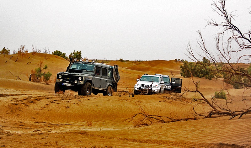
After refueling in Jandagh, we redirected north again to reach teachers at the junction of Jundagh with a dock. This dock is a remnant of the place where the caravan road crosses Jundagh to Bidistan and Torud. This dock was the last resting point of the caravan on the desert coast. There are two other docks on this route, the Middle Dock and the Sarkivir Dock, the former built in the middle of the route and the second on the northern shore of the desert. From the craggy dock to the west, we reach the puffy terrain of what is locally called the “cave”, a 60km route that requires a lot of time and energy to drive there due to the overburden. Slow. The entire distance traveled at an average speed of less than 20 kilometers per hour until the group reached the famous sandstone wall of Rig. The wall, about 90 kilometers long, is the tallest and most eastern wall of the Rigid Jungle. The first night camp was set up on the periphery of the wall and where it was somewhat free from wind attack. At 6 o’clock in the afternoon, the weather was mild, with mild winds blowing from the west and clouds accumulating and ambient temperatures around 8 degrees Celsius. From this point, a view of the towering heights was visible in the southeastern view, except that only the vastness of the desert was visible. Exhaustion due to the difficulty of the route and the length of the road made it complete silence at 9pm throughout the camp.
second day
After having breakfast and meeting for information and reminiscing about the environment, we moved on to the northeast of Rig Jen, doing teamwork as well as loading cars. Moving northward on the margin of the fifth wall of the Rig Genie, after a distance of about 15 kilometers, we cut the fifth wall and two walls and entered the northern plain of the Rig Genie. Due to the presence of clays (cave caves) east of the fifth wall, the group’s velocity to the west of the wall seemed to increase. Crossing these walls was also difficult. The drying of the sands has resulted in the trapping of several cars that have been liberated by various methods, including the use of long belts and winches. After crossing 4 sandy walls, we entered the northern plain of Rig Genie. In this area, the group, as a memorial, placed souvenirs inside the bottle and buried it in the northernmost part of the Rig Jinn at half a meter deep. It is about 50 kilometers from the point north of the sand jungle sandstones to the central plain of the sand jungle, which is covered by puffy clay-sandy soils. Moving on these lands, due to the light soil, put a lot of pressure on the leading car. Therefore, the leading car would be replaced every 15 minutes to relieve the pressure on the cars. After 2 hours of driving and passing through the confluence of scattered sand walls, we reached the center of the Rig Genie in the central plain of Rig Jen. Here is a memorial to the desert and desert groups of Iran and other groups years ago, where we set up a banner to commemorate it and continue south. Within 10 kilometers of the junction of the 5th wall of the Jinn and Tailgate one of the group cars had a petrol hose rupture. The repair of the torn hose was completely unloaded, and after an hour and a half of continuous effort and creativity by the repair team, we were able to fix the problem and move on. We quickly moved south and into the tailgate area and set up camp at night on the fifth wall and tailgate. The air temperature was higher than the night before but increased with the wind. The second night camp was set up at the last moments of the sunset and in the dark. Unlike the previous night, the camp ended with all the team members discussing different topics and discussing the upcoming days and meeting more friends with Rig Jen and Desert.
third day
On the anticipated route crossing the tail-ridge, a new route record was anticipated in the area. On this day the temperature had fallen sharply and the rain had begun before dawn. Due to last year’s experience in the Rig-Jen that the sudden drop in temperature caused the tires to get out of the rim, all cars increased the tire pressure and made a serious visit to all cars throughout the day and at all stops. . After reloading the cars, we headed 10 kilometers to the west and then went into the sandbag section of the tailgate under heavy rainfall. The tail of the sand consists of four east-west walls, the third wall being the tallest sandstone height of the sand, with a height of about 150 meters from the bottom of the desert.
We successfully passed two walls. The path filled with sand funnels and the slightest mistake was enough to stop the group for 1 to 2 days. Crossing the third wall was a bit time-consuming to cross the previous walls. Increasing the height of the nested hills and arches added to the complexity and difficulty of the route. To avoid any accident, the leading car along with a back-up car went further than other members of the group in search of a suitable route. After 4 kilometers we were able to find a way to pass through the nested hills. Eventually the route turned slightly west and all the cars passed the difficult sandy road safely. It should be noted that among the walls were sandy valleys filled with typical shrub and vegetation communities of the desert areas that created beautiful, exquisite and unique landscapes that tired the eyes of every deserter and passenger. After crossing the second and third walls, the largest sandstone forest appeared in the valley. Enchanting, magical and pristine view. As we approached sunset time, we quickly passed through the meadow and reached the fourth wall. Due to the dark weather the leading car was trapped inside a sand funnel. To get the car out of the hopper, we had to use two winches with two reels to double the lifespan by increasing the towing force successfully and minimize possible damage. Due to the darkness of the weather and the difficulty of the route, the decision was made to split and set up in one of the camp’s fourth wall funnels. The third night ended in a heartbreaking conversation with members of the group who had become more familiar with the complexity of the route and the need for full cooperation and continuous teamwork.
Fourth day
At the beginning of the day, the team behind the car had to make an unwanted jump, causing unnecessary bumps on the front wheels and breaking one of the poles, due to the unusable footprint of the front wheels and the choice of a harder path to cross. And in practice, the front wheels of the car were removed from the powertrain and lost their performance. But due to the proximity to Hajj Baqir and the end of the Rig, we decided to continue the route the same way, and eventually the vehicle was able to continue its journey and finish without the slightest problem. After 40 kilometers of sand dunes, we entered a river and headed towards Hajj Baqir on the west side. All members of the band left Rigg at 6pm and ended one of the most difficult experiences of the band.
Climate (Weather)
The Rig-Jen area is part of the central plateau of Iran and has a similar climate to the margins of the plateau.
The central part of Iran consists of a large plateau surrounded by high mountains, which prevent marine moisture from penetrating the area. Much of this is in arid and desert climates, where evaporation exceeds atmospheric seepage.
Seasonal climate change, including sunshine, is very high in the sand, and summers are very hot and dry.
Due to the lack of meteorological stations in the Rig Genie, only the marginal cities of the region can be cited. The absolute minimum temperature of Garmsar was recorded at 4.8 ° C in February and the maximum absolute temperature of Garmsar was recorded in August 79 with 43 ° C. Based on the above statistics, considering the range of + 5 ° daytime and – nighttime temperatures, it can be assumed that the temperature of the northern part of the Rig Genie varies between -1 and +48 ° C. In the southern part of the Ridge due to proximity to the sand dunes of the Ridge, this temperature rises and increases to +50 ° C in July.
The highest average humidity was in December with 71% and the lowest relative humidity was in June with 22%.
According to ten-year studies (65 to 75), the average temperature is above 8% of relative humidity, 50% relative humidity, ie, the climate is extremely dry, and over 4 months of the year, cold and rainy season, relative humidity prevails. The air is somewhat humid.
Vegetation
The dry climate and soil composition (salt and gypsum) make the plant growth very difficult and slow. In the swampy and lowland areas of the north and the center of the Rig Genie no vegetable life is visible. Only in areas with snow cover behind the western slope can one rarely see 1-year-old oak shrubs, which dry out mainly due to drought and climate. But on the periphery of the Rig elephant and the tailgate region, the situation is changing. In these areas, only plants capable of being resistant to drought and salinity are able to adapt to the harsh climate of the desert. Some of these herbs include: Salsa, Ashan, Talle, Gaz, and Camel Thistle.
In the northwestern and western regions of the Rig Jen, there is a thick and tall stem of Rhona bushes near the Black Mountains and Nakhijir, which are used for fuel consumption, some of which are also used for dyeing. .
The vegetation of the steppe zones of the Rig Genie margin includes wheat, wild barley, barley, mint, wild lettuce, and Mir Hassan, which are annual and herbaceous plants in the region, as well as scab, caravan and bush plants.
The vegetation in the Dum Rig area is covered with sandy shrubs and rarely Scanbill. As we move westward, the cover becomes thicker. Other plant communities in the sand include Nassie, Cow Tail, Nettle, etc.
Biodiversity
A large area of the Jinn Ridge lacks vegetation and animal dispersal. No complete information is available on the vegetation and wildlife status of the area. But on the outskirts of the mountain, at the mouth of the Wolf Wolf and at the narrow crater of the darkness, as well as the Kafr Kuh slopes, the existence of an Iranian grave and grave has been reported. Typical biodiversity of desert areas is visible in the tail-ridge region due to the moderate desert hardiness and increased vegetation cover. This biodiversity includes sand fox, sand cat, caracal, rabbit, jerky, pamswak, pike, snake and scorpion, agama and jacko, hawk, desert sage, golden eagle, wolf, jackal and more. It was also home to deer herds during the reign of Shah Abbas, probably extinct due to hunting. The Jinn Rig is adjacent to several protected areas, including the Malahadi Forbidden Hunting Area, Abbas Abad Nain Protected Area, the Ardestan Forbidden Hunting Area, the Shepherd Hunting Area, and especially the Desert Desert National Park, which can be found in the area. It was believed that many wildlife in these areas also live in parts of the sand jungle.
Water Resources in Rig Genie
The largest river in the northeast area is the Jebel River, which consists of several tributaries. Other streams that flow into the Rigid Jen can be traced to the water collector (Roodsar Valley). The river has very little water that is salty and unusable.
The Ramah River or the Tang Chahar Talegh River is also a seasonal river that originates from the northeast highlands of Garmsar and the area of Leszora, and then joins tributaries such as Khoshabudrud from north to south toward the Deh Salt River and extends into the Rig Genie. Shrink. In the northern part of the Rigi Jen, the Vergi River flows from the heights of the Sulfur Mountain and enters the RW Jen in the northwest-southeast direction.
In the southeastern part of the Ridge Jinn is the Zorvmand River, which originates from the Zorvmand Heights and flows along the Jaw Rig to the east-west wall.
Inside, there are no water springs, except for some very salty and bitter water springs, which are on the fringes of the scattered heights and at great distances.
Civilizations and man-made works
In the interior of the Rig Genie no traces of human construction and no traces of civilization are visible. There is neither a town nor a village. In the history books there is no mention of a village within this region. What has been and remains is just on the fringe of the Jinn.
Jandagh is one of the sandy beaches of the Rigid Jungle, with a very up and down history, which has seen the magnificence of its work that has been lost for many years. The distance between Jandagh and Torud was one of the impassable areas at the time that attracted many visitors. This deadly wilderness had created such a huge divide between the south and the north of the country that it had to pass at a certain time and with great facilities and detailed planning to reach the northern regions. Sun Hedin has considered the ethics of the people of Jundagh in the south of the desert and of the Bidistan and Torud settlements in the north quite different.
Anarak is another well-known settlement in the south of the Rig Jinn. The current location of Anarak during the reign of Shah Abbas Safavi was fresh water and a small pomegranate tree, and the convoys that then transported goods from Nain, Ardakan, Zawar, and Ardestan through the Central Desert to Semnan, Damghan, Shahroud, Varamin and Garmsar. They passed through that spring and used the rangelands, the spring water and the dock for their camels. One of the camels of Khorasani named Mohammad Kata (the hero of Muhammad) came to this spring and used the natural position of the place to loot and seize goods and cargo of the caravans and acquire the property thereby. In his impassable shelter and cave, Cal Muhammad hid a cat until news of his robbery finally reached Isfahan, the capital of the Safavids, and King Abbas ordered several marines to go to the land of Anarak and rob the convoys. Arrest. Upon hearing this news, the cat was hiding in his strong shelter until the Marines reached his shelter to arrest him and he was able to disarm them and take them to Isfahan. He apologized to the Shah for his behavior and was pardoned and appointed to the Anarak guard.
Ashin Ashin One of the villages on the southern margin of the Rig Jen that has been mentioned during the journeys of Sun Hedin and Alphonse Gabriel. The existence of minerals and ore deposits in the rocks of the Ashin ophiolitic complex has been studied as a remnant of past seas and waterways in Iran.
Babakhald is an area currently used by shepherds and sailors. This area is the last point south of the Rig Genie, where potable water is supplied through small aqueducts. Next to the aqueduct, there were several mulberry trees and palm trees. Near Babakhaldi there is a science that is probably used to mark the route and there is no more ruins left.
Haj Bagher Abadi is a small village located south of the Rig Jinn and east of Babakhald. The name of the village is derived from the science on the mountain overlooking the road.
Pass History
About 30 kilometers south of the center of the Jinn Rig, at the junction of the fifth wall and the tail of the ridge, are black rocks that are slag-smelting minerals. The slag has been abandoned here after the smelting of copper extracted from the heights of the Big Mountain (Mount Mahalladi) and other copper mines in the region. This method of metal smelting in Iran has a very long history that has not been used for many years. In this method, black shrubs are used to ignite fire and melt metals. Due to its high fracture ability and high fire resistance, this plant species is mostly cut and exploited and burned in melting furnaces for melting minerals and metals. Vegetation is thinner in the place where the slag is left than in other places around. This confirms that the flies have been used in the area, and it is enough to admit that in the past there were those who had access to the Rig Genie Center without even naming them in history.
Alphonse Gabriel in his book Crossing the Iranian Desert mentions a trip from Ashin to the brides on the outskirts of Rig Jen (1930s). In his book The Desert of Iran, Sun Haddin mentioned his trips to the Ridge Jungle (1900) but never succeeded in crossing the Rig Center. He called the area insidious and refused to enter it. He also noted the existence of several routes within the Rig-Jen that received information from area shepherds.
Ali Parsa writes in his memoirs about his early acquaintance with the Rig Jen: On one of my trips to Central Desert I encountered Rig Jen on a map. His name seemed mysterious. I decided to go there and it coincided with the Iranian Revolution. Years later, in 1996, this dream came true again with a trip to Desert National Park. My friends, and Mr. Miranzadeh, then head of the Desert National Park, decided to fly over the Rig Jen by plane to prove to us that it was not strange. It’s just salt and sand and hills. The first surprise we encountered in the Jungle Rig was a new pit. Inside the pit there was a blue area that was salt water. The crystallized salt was white around it, and the surrounding brown color was known to be dispersed by pressure.
The Legends of Rig Jen
The ancients considered Rig Jen to be the dwelling place of demons and demons, in which every human being embedded in their anger and anger would not survive. They also considered the movement of sand dunes and their deformation due to the presence of evil powers in the area. What is known is that most of the sand jungle sandstones are constantly moving and moving due to the lack of vegetation under the influence of wind force.
Hedin tells the myth of the people of the time in the desert desert of Iran, that there is a lost paradise in the center of the sand jungle. In this paradise there is a lake and beside it are rainforests. The wool devils have left the camels there and whoever reaches this area will be rich. Certainly there is neither a lake nor a forest in the center of the Rig Genie. What it is is puffy clay soils that do not have the potential for evaporation and salinity for plant growth.
The press and the press have likened the Jinn to the Bermuda Triangle. Rig Jen is nothing like the triangle and not the lush Bermuda beaches! Neither the Earth’s magnetic waves differ from that of the rest of the world, nor did the aircraft crash over it. It is out of the question to deal with all the legends of the Jungle Rig but what about the Rig Jen is the sky and the earth that has made it the land of legends. What should be taken into consideration when traveling to such areas is sufficient technical, safety and experience experience. The desert, despite its quiet and patient appearance, has a rough and dangerous nature. Traveling to such areas requires special arrangements, and without the necessary studies, it will certainly have disastrous consequences.
At the end, the Honorable Master Kiyomars Babazadeh deserves the constant accompaniment of hard trips, Ali Garmaki, Amir Ali Delfan, Masoud Kheirkhah, Pedram Saeedi, Diako Rezaei, Fouad Hosseini, Mehdi Najari, Kian Babazadeh for navigation and navigation Nasibashi Siavash Khazaei for the logistics and other travelers who would not have been able to make this trip without the efforts of each of these dear ones.


