The Central Iranian Desert (also known as Desert Hole, Desert Desert, and Salt Desert) is an uneven triangular geological hole with the base of the Tabas Mountains to the Sabzevar Mountains in the east and its two sides one of the southern highlands of the eastern Alborz and the Semnan Mountains. To the north is the other highlands of Tafresh and Kashan and the Anarak and Jandagh mountains to the south. Inside this hole are two basins, one in the Maghreb and the other in the Eastern Desert.
The central salt desert is located in the largest desert area of Iran. Its east-west length is about 2 kilometers and its width from north to south is between 150 and 400 kilometers and its area is between 2 and 3,000 square kilometers.
Due to the size of the region and the structural differences between the western, eastern and central parts of the central desert of Iran, this article will examine the central parts of the southern to northern desert. For a discussion of the western regions, see the speech by Rig Jen.
Read More ...
The central desert basin is one of the lowest points in the inner plateau of Iran. In the low desert areas, there are single mountains of salt that are conglomerate and granite, probably due to tectonic movements and are more resistant to erosion because of their hard material.
The salt desert is very different in structure from the Lut Desert, which is a hollow hole formed by the fracture of the ground floor, while the Salt Desert is a large geological hole. Most of the desert area is rich in salt deposits and most of its sediments and erosions are formed from eroded slopes of Alborz.
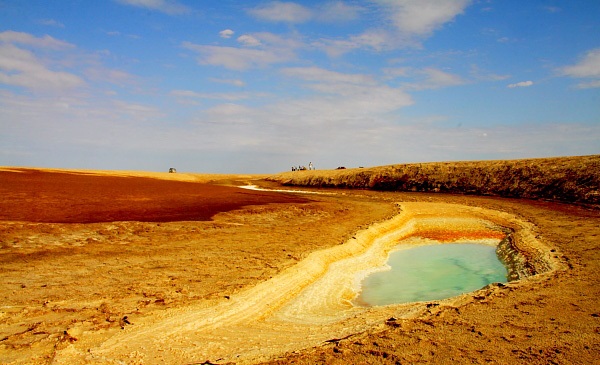
Most of the salt desert center is covered with salt clay soils that have become highly irregular due to surface scattering precipitation. Salt platforms (salt lakes) are visible in the southern and central parts of the desert. Underneath these layers of fat sludge are dark brown and green cases, which are absorbed by the heat of the sun and the pressure of the parallel layers in parts of the desert on the ground and dried, known as the desert floor. The reason for the sharp and explosive forms of black salt in the region is because white salt passes the sun’s infrared rays. The best surface to absorb these rays is the black sludge of the substrates. These sludges are heated by the absorption of the rays and expanded, causing the surface layers to break down, leaving the surface to desert. These black sludges, after being dried by wind erosion and rain, are sharp and winning shapes that virtually make it impossible for the car to move and four ends. Also on the border between the desert and desert are yellow colored soils known as yellow flowers and generally of sulfur compounds. The presence of the mentioned textures has given the desert unique ecological diversity that can be very suitable for tourist attraction.
On the southern margin of the desert, the desert terrain is mainly covered by Bakharan sand dunes and typical pyramidal sand dunes and typical vegetation of Iranian desert areas such as Gaz, Taq, Ashnan, Scanbil, Tail Cow, Nassi, Gheich, Espand. It is also visible at the beginning of the desert basin of their scattered shrubs. With the increase in the percentage of salt in the soil, no plants are visible. Salt domes and alluvial plains are found on the northern margin of the desert.
According to geologists, the central desert of Iran has been a shallow sea called Tethys in the past, which has dried up over time due to warm weather and climate change. The Caspian and Aral lakes were remnants of that great sea. On the eastern margin of the desert, there is a village called Younis near the city of Bajestan, where residents believe Prophet Yunus (AS) was swallowed by the whale in this sea. The presence of layered sediments in the desert can also substantiate this claim, as are areas such as fossils in the Desert Desert National Park area, which is covered by various fine-grained fossils.
Desert Supply
It is not clear exactly when the word desert came into Persian. Some believe that the desert originates from the Arabic word grand, and the desert means a large and vast plain. Since the area has in the past been home to Asian graves (unfortunately no recent burial in the Central Desert region), and blind in Sassanid means simple, it can be deduced that the desert is of Sassanian origin. The word blind is taken. Also, in the Persian Pahlavi, a cup or bowl means a cup or bowl, and since the desert is like a bowl enclosed in the mountains, it can be a source of desert. Other words refer to the khafra, which is of Arab origin and continues to desert in the desert of Africa.
Vegetation and animals
In the central part of the central desert, no bitter or freshwater springs are visible (in the Rig Jen area to the west of the central desert as well as in the eastern parts of the desert there are scattered springs that generally have bitter blue water) due to the lack of fresh water resources And the plant in the desert area of this area lacks animal cover. On the southern edge of the desert and on the desert border, animal cover includes rabbits, cats, sand foxes, Jabir, Jared, Sargpe, falconry, flywheels, snake bears, camel snakes, parsley snakes, serpentine agama, black and Arabic tails and Scorpio species include golden, black and tailed scorpions and can be seen at whole heights, goats and jabir. (Click to see desert animal cover)
Desert Roads and Highlands Water
Due to the eastern western slope of the desert, all waterways, seasonal rivers and marshes have a western-eastern direction. There are 3 major rivers in the desert. 2 rivers in the southern part that originate from the scattered heights around Rig Jinn such as Mount Zommand and Mullah Hadi and the southern highlands of Egypt, and 1 river in the northern part that originates from the Semnan and northern highlands of teachers and desert. Seasonal chickpeas, which feed from the southern highlands of Mohammad Abad-e-Kurzak and Arousan, also enter the Southern Desert in two waterways.
There are no mountains or hills in the entire desert area. The desert is a flat, flat area that lacks any significant elevation. The average height of the desert is 720 m above free sea level and the average annual rainfall is less than 10 mm.
temperature
The warmest temperature in the warmest day is about 50 degrees Celsius and 25-30 degrees at night. This sharp difference in temperature causes the rocks to crumble completely. In the cold seasons, the daytime temperature is about 13 to 17 degrees Celsius at night from about 0 to -7 degrees. On the fringes of the desert and near the sandstorms, the air temperature rises dramatically throughout the day.
Antiquities and monuments
From the historical point of view, except for a few scattered reservoirs along the desert crossing paths, no visible archaeological remains have been identified in the area. The ancient cisterns in this area include the headwaters of the desert, the middle, and the caverns, all of which are located on the periphery of the teachers-to-Jandagh border. In the desert regions of the desert, there are various antiquities. Biabank area An old area (roughly equivalent to the present-day estuary and biabank) on the southern margin of the Kavir plain that was formerly on the way to Isfahan (Nain) to Khorasan (Neyshabur). There are indications that the area was inhabited before Islam, including a fireplace on the outskirts of Mehrjan village. The city of Jundaq is also known as the Anushirvan Dadgar Prison and Exile in this area and boasts an old dome called the Eight Doors from the Sassanid era.
Prior to the eighth century, little was known about this area, but during the Safavid era, King Abbas I headed for Mashhad and, on his way, encountered sand and ordered to set up brick columns for travelers. Columns that are still visible in parts of the central desert (the route to the village of Brides). At his behest, for the comfort of Mashhad Razavi, a farm and a ligature were also built, known as Abbas Abad Farm. In 1007, his troops went to Khorasan by the same route.
Due to the enclosure of the desert, many ancient Iranian customs have been preserved in the desert, including the celebration of the last night of March, known as the Bibur night, which residents believe the blessed angel descends on their home. Comes and blesses them. Until recent decades, the celebration of Sadeh was common in the area, and some villages and villages were celebrating the day with fire.
One of the ancient and historical monuments of this area is the castle of the village of Baadeh (Orange Castle) in the Sassanid style. The base of the castle is about a thousand square meters. Inside the castle are five-story winding chambers and corridors, formerly a grain store. Next to the wall of the castle is a mosque, which was repaired by an eighth-century master. There is also a dilapidated building called the “Seven Brothers” and the tomb of Imamzadeh Ibrahim, attributed to one of Imam Musa Kazem’s (AS) children. Located in the local cemetery known as the Cemetery of the Dead, the cemetery narrates those killed in the battle between the Alawites and Sohrab Gabor. In Mehrjan Mazar Aref and Sufi Biabanki, Shamsuddin Haji Mohammad Shah has remained in place since the eighth century. There is an old mosque in Farrokhi with a large dome and a porch and a building called the Sheikh’s Mansion, which is very old. There are several quadrilateral works in the Farrokhi cemetery, one of which is known as the Old and has a sacred side. Ardebi is a prisoner known as the court of Masood Lashkar-e-Yogi, Haj Ibrahim Bek, son of the late Nayab al-Hakumah of Jundaq and Biabank, whose home is Saroj. Also in the Jandagh house and the tomb of the poet Yaghma Jundaghi of Qajar poetry.
Ancient Routes
The most important and most popular route used by caravans is the Jundagh to Bidestan road, which is the communication center of the Jundaq teachers on the same ancient road. Other routes include the Bride Route and the Bride Route to Helwan. The bride-to-helmet route has rarely been used in past times due to the presence of very hard, sharp and winemaking floor and floor textures that injured the camels’ feet. In the book of Iranian deserts, Sven Hedin the Swedish deserter has written her memoirs about crossing the Jundagh to Bidistan and the wedding to the bridegroom. He also intended to cross the route of the brides to Helwan, who, after speaking with the locals and aware of the potential dangers, ignored it. The lack of vegetation in most of the desert area along with the lowlands have caused the slightest rainfall to cause massive clayey marshes in this area. Therefore, it is not recommended to cross the desert without proper studies and careful review of the rainy months.


