Abstract: The Masile area, which is largely covered by the EPA (Desert National Park), has a variety of forms of elevations, lowlands, short and steep slopes and mountain ranges that are part of the In the past it has changed due to biological factors or due to the activities of ranchers and farmers in neighboring cities (Varamin, Garmsar, Kashan, etc.) and its nature has changed and consequently forest rangelands, desert and some Farmland and rural areas form the deformed parts of the region. The desert has never been without human life, but has been transformed by geographical and historical circumstances. The desert illustrates a reality that human beings from the pre-historic past lived in different traditions and ways. Significant signs and effects exist that prove the social and economic life of these people who have played a significant role in Iranian civilization and culture.
Read More ...
Siahkouh area
Geographical Location: Sichkouh region is located in the western part of Kavir plain, 140 km southeast of Tehran, northeast of Salt Lake and Kashan, Aran and Bidgol counties. The area has latitude 10 and 52 east and latitude
Specific features of the area, including desert climate, water scarcity, salinity, and lowland vegetation, have made it difficult to concentrate much of its habitat and population in populated areas, and wherever conditions arise. Needless to say, several cities have been formed:
Garmsar city in the north, northwest, Varamin and Ray, west, Qom and southwest, Kashan and Aran and Bidgol. Nearby cities that form humanitarian centers and are close to the Siahkouh area include:
A to the north:
1- Varamin city and its southern part called Behnam Arab (Tehran Province).
2- The villages of Eradan, Rikan and Gheshlagh in the southern part of Garmsar County.
B. In the South:
1- Aran and Bidgol district of Kashan city and Abuzid Abad village (Kashan city).
2- Qomrud from the outskirts of Qom province.
Among the central highlands of the desert, Sihkouh is the most famous of all. From a distance, it appears as a prominent, black mass with large cuts, but the height of the mountain is not high and does not exceed 1500 meters. Siahkouh is due to altitude differences with the surrounding plains at around 800 meters and steep slopes like a high mass in the middle of the desert, where elevation differences cause the air to differ and are usually snowy in winter.
The area is low-lying, arid and low-water, and there are springs in the slopes, the most famous being the Shah. It is also bitter and salty. Livestock use it as needed. There is no drinking water from the spring from Siahkouh to Taleh Mountain and White Water Mountain, but in the Siahkouh rock pits until late May rainwater is collected and these areas are called “water rocks”.
In the past, the area has been home to nomadic herdsmen and ranchers for a long time, and now it is banned as the central park of Iran. In essence, there were two causes of life around Siahkouh: the first use of natural grasslands around the area in the winter when ranchers and Varamin came, and around Siahkouh, the Black Tents, suggesting a nomadic and nomadic life for the people There were far and near villages and Garmsar and Varamin towns.
The second issue is the emergence of mines in the Najjir Mountains used by them, and a line of communication between Najjir and Mubarak crosses the northern slopes of Sihkuh, and this area may be a safe haven for the rebels who rose up against the central government It has been, like Sardar Tile (Hussein and Mashallah Khan Tile and Mohammad Khan Siddiqui). Preserving and preserving plant and animal resources in the area are currently being created by the EPA through the creation of the Desert National Park around Siahkouh.
weather
The meteorological stations in the northern slopes of Siahkouh are located by the Meteorological Organization of the country. Nearest to Siahkouh are Garmsar and Varamin weather stations. According to statistics from these stations, the amount of rainfall in the Siahkouh area is 145 mm / year and the average annual temperature is 17/80 ° C. Rainfall varies between 50 and 300 mm depending on the year, with most of the rainfall occurring from November to May, and snow usually falls in January and February in the region. The temperature is also minimal The degree varies up to 44 ° C. The climate in this region is very hot and dry in summer and cold and dry in winter and desert. Winter and spring rains in the Sihkouk highlands, especially with a significant increase in summer temperatures, cause a small amount of saline springs flowing through the northern and southern valleys of Seykouh. The only permanent fountain is the Shah Fountain in the Shah Gorge, where water is sent to the environmental outlet for consumption (non-drinking). The length of the fountain to Bahram castle (inn) is about seven kilometers, which used to lead the water to the inn by using stone gutters, which use polka ducts because of the damage.
A. Historic Caravan Roads:
Natural Complications: The Bahram Palace (Shah Abbasi’s inn) in the Siahkouh area was the most important center of communication between the east and west of the desert. So that Bahram Palace was also a communication base and a trading place for merchants. The merchants entered the area with their convoys from Isfahan to Aran and Bidgol, crossing the Maranjab caravan to Ein al-Rashid and the palace of Bahram, where the general decided to exchange goods or transport goods to the cities in question. They would get it. Here are three ways each one goes along:
1- The road from Bahram palace to Pishva and Varamin and Rey city which is about 60 km to Mobarak village and then to Hesargholi, Askarabad, Qala Band (Aberdej) and then to Pishva, Varamin and finally to Rey and Tehran. has arrived. The distance from Tehran to the caravanserai is about 140 kilometers, which has only been used for a year. Because it is very hot in the summer and spring due to the proximity of the desert, it is dangerous to cross it because of the floods.
2- Bahram Palace on the northern slope of Siahkouh to Garmsar and vice versa.
The road starts north of Garmsar and crosses the stone road (about 35 to 40 km) to the south of Garmsar town and after crossing the Strontium mine to the Shah Abbas Abbey known as Bahram Palace. Arrives. The road is about 65 kilometers long and can only be crossed in dry seasons.
3- Kashan Aran Road to Maranjab:
It is the road from Kashan to Aran and Bidgol and then to the four arches and the Maranjab inn in the south of Salt Lake and from there to White Abat (environmental checkpoint) and the road to Bahram palace that caravans to Garmsar and Varamin and Ray was directing this route from Kashan to Aran and Willow Flower, to the Safavid Grand Inn near a marjab aqueduct pool known as the Maranjab Inn (2) and the way to the inn. Maranjab is connected to Ein al-Rashid and Shah Abbasi’s inn (Bahram’s Palace).
4- Abu Zayedabad Road:
It extends from Natanz to Imamzadeh Aqa ‘Ali Abbas to Abu Zaid Abad, in the plain of Qasim Abad and reaches Bahram Palace (Shah Abbasi’s inn) in the White Sea, east and south of Siahkoh. These roads are caravans that have taken the title of commuter by traffic.
Mountains
Around the Masilah Basin, there are mountain ranges that separate the area from the adjacent areas, the most important of which are:
1- Twelve Imam Mountains: Its altitudes are of alkaline volcanic matter. This mountain lies northeast of the Masilah plain and extends west to southeast, which is essentially parallel to the salt lake margin to the desert plain. The highest peak of the mountain does not exceed 1800 meters.
2- Siahkouh: Singularly located on the eastern margin overlooking the salt lake.
Although it is best known for all the elevations around Lake Salt, it is famous for its low altitude (211 meters) due to its special time on the Old World communications route. Sokhkoh in the northwest is connected to the twelve heights of the Imamate, which originally formed the dividing line between Maslah and the Desert Plain. Sihkouk is a mass of volcanic material surrounding the Tertiary sedimentary layers and resembles a building To the bulb that is cut in half.
Sichkouh monuments
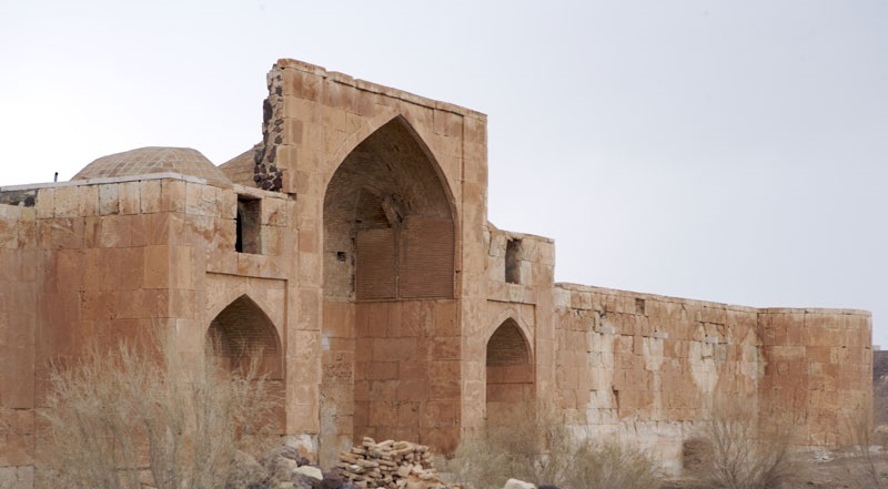
There is no major road or communication link between Siahkoukh and the Salt Sea Desert. From the not-so-distant past, the Sichkouh area has been an important southern-northern communication route. From the remaining monuments such as Maranjab caravanserai, Bahram palace (Shah Abbasi caravanserai), Ein al-Rashid and Sefid Ab, it is known that in ancient times the old road of Isfahan, Kashan, Garmsar and Khorasan and northern Iran passed through Siahkouh region. But in the writings of Islamic geologists there has been no discussion of the way of Siddiqua. In the early days of Islam, the Isfahan route to Khorasan was via Nain, Tabas, Tariz, and Neyshabur, but as long as Rey had credit, the roads of Khorasan, Azerbaijan and Mazandaran had passed. It seems that the road to Isfahan has been abandoned after the demolition and decline of the Ray period, and in the Safavid era, special attention was paid to the restoration of the communication route between Isfahan and Khorasan. In the 17th century, the French tourist taverna points out that some inns near the dunes are adjacent to the communication routes. There are several prestigious buildings in the north of Siahkouh, the largest of which is known as King Abbas, about two kilometers away. The palace of Ain al-Rasheed is located next to the palace, south of the King Abbasid inn.
During the reign of King Abbas I, alongside the country’s roads, they began to construct buildings, some of which were usually at the intersection of public roads, such as the King Abbas’s inn at the Bahram palace. The palace, known as the Palace, has an exterior facade of smooth, pink stone, with two doors facing north and south. The exterior facade stones are 60 to 70 cm in size and are used to build the entrance gate and porches of the larger masonry. The building map is a bit different than the famous caravanseries of old.
The entrance gate is covered with two platforms and two adjacent rooms on either side. Inside it is a large courtyard surrounded by small rooms and the yard body at the bottom of the masonry like the exterior and above the carcass with limestone. Is. The ceilings of the rooms are of brick and are covered with gypsum in the courtyard and in the walls and walls. In the western body of the courtyard there is a chamber with a king and niche around and a porch in the front and a large underground hall below. Behind the buildings inside the courtyard there are stalls with numerous mansions, and next to each manger is a platform for resting stools and stoves for cooking.
Drinking water and drinking water are about seven kilometers from the Shah spring at the foot of Siahkouh to the palace. It is a large, interconnected boulder that measures one meter to three meters long. The boulders are shaped in the middle in such a way that the two ends of each male and female are shredded to lock and clamp the stones together so that the stones are well intertwined and prevent water loss. Even in deflections, the stones are marked with triangular marks so that the two sides that need to be connected are known. Over a distance of seven kilometers of the creek, three ponds were built for the water reservoir. Water stored in the basin to make the water easier to flow In some places, there is an underground conduit along the creek to prevent excessive evaporation during the warm season.
Along the path of this rocky creek, to the south of the Shah Abbasi caravanserai, there is a brick building and the map indicates that this caravanserai and lodging place were not open, as there is an entrance door to the main hall on either side of the two large halls. The halls have a niche that is symmetrical to the lower and upper corners, and to the south of the courtyard there is a building like the front halls. In the middle of the courtyard is a ruined stone basin where the water of the Shah spring first flows into the basin and then through the stone basin to the inn near the palace. Originally the building’s history is not clear and may have been repaired several times. Underneath the walls, a brick body has been raised on the carved stone walls. The bricks are very old and thin. On the stone foundations, they are fastened with bricks where they are newer and white, and the ceilings are of the type of repair bricks, so it can be said: The main building is entirely of masonry and the ceilings of the building do not know how it was built. The basement floor is also adorned with very old bricks, which can be thought of as a stone building rather than an old dilapidated building, and the older bricks found beneath the walls belong to the newer era, as well as white bricks. The color of the ceiling of all rooms and all ceilings.
In the entrance and entrance hall of the building, between the empty bricks was a tile inscription that today has no trace left and the ceiling of the halls has collapsed. In the southern part of the Shah Abbasi caravanserai was the exclusive residence of the Shah and the princes who traveled from this place to Khorasan and Farah Abad Sari.
Ein Rashid Building
Another building, known as the Ein al-Rashid Palace, is two kilometers southwest of the inn and the palace. The building is made of brick, but it is not a rocky path but rather a little sideways. Opposite the ruined basin and to the southwest of the building there are signs of sulfur hot springs appearing between the gypsum and marl, with temperatures between 17 and 18 degrees Celsius, which is why it is known as Ein al-Rashid. This spring from the underground conduit, mineral water entered the pond. But inside the building and around it there is no pool or water storage, and since this is not potable water, it should be assumed that the Ein al-Rashid palace was built to use mineral water. The small palace of Ein al-Rasheed, in the brick hallway of the entrance, reveals tiles and inscriptions, built inside the courtyard of the small rooms on both sides of the backyard and behind the stables.
The brick ceiling of the rooms is all shattered, but the heavy roofing of the ceilings does not damage the wall because the fuselage of the fountain wall is broken, the building broken down, and the plaster floor may be weakened. The following has led to the erection of the roof and the demolition of the roof, which has fortunately been completely restored and restored by its cultural heritage.
The building of Ein al-Rashid has a special beauty. The brick-and-ceiling bricks are lined with geometric motifs, and the brick frames show the former location of the inscriptions and tiling, and are known to have been close to the tile since there was a imprint inside. It is said that government officials (Raqim) have come to the area to arrest the thieves and seize stolen property and have taken some tiles. What is known from the chronicles is that before the Safavid era, a name was given by Siahkouh and the building. Not. Alexander the Great in Abbasid World, Volume 2, mentioning the good works and the construction of the building of Sefkouh interconnecting building and the Sari Salt Road, the Black Mountain, which is fortified with stone and lime (40 km stone road) and ten thousand dollars. He knows Shah Abbas’s works, but the skill and skill used in building the palace of Siddiqua is far from how the Safavid era was built.
Bahram Palace (Shah Abbasi Caravanserai) Siddiqua has been repaired several times. Underground and brick masonry beside the rooms are examples of various repairs, and the walls of the room contain several plaster layers, each containing a time-lapse layer and, as the case may be, written Remembrance of the door and the wall of the room, which is a blasphemous act, helped to illuminate the history of the palace. Memoirs are different and often associated with poetry.
The style of brick palaces is usually from Safavid and Zandieh times, but the stone palace is much older and may have been demolished several times and has been rebuilt since the time of King Abbas because of the use of polished masonry in the palace body. And the stone creek shows that the main building of the palace was not for the caravanserai, and none of the inns in the Safavid era had a history of this style, and it is not unlikely that the stone palace was very old or that the private residence of the ruler or royal building was on the way. Is. On the western slopes of Siahkouh, on the way to Varamin to Kashan, is an old and dilapidated dilapidated water reservoir called Qilokhah pond. Around Siahkouh and Sefid Ab, there are several specimens of these water bodies called docks. The pond is built in a hollow, 10 to 20 meters in diameter, with a hole in the floor and walls and a dome roof over it. Around the pond ducts from the surrounding land reach the pond pond, which is filled with rainwater from the pond in the rainy season and is constructed on one side for water harvesting.
Paving Road: In the north of Bahram Siahkoukh palace, the ancient work in the desert between Isfahan and Garmsar is known as the Paving Road. This rocky road is 6 to 10 meters wide and is 35 kilometers short of the flat desert terrain around which it was named due to the use of large rocks. This road crosses the western slopes of Siahkouh and Qaghlokh and Agh Mohamad ponds, and on the non-desert lands to White Springs and Maranjab Caravanserai and on the other side to the north of Zomrod and Garmsar deserts, to Deh Rashma. It reaches Garmsar block and this route is known as Shah Abbas Road. But it is not paved in the whole distance, and it is only in the northern part of Siahkuh in the Garmsar deserts that it has been paved.
Maranjab inn
The eastern area of Masilah has long been a major communication route mentioned in the preceding pages, between Isfahan and Kashan, Garmsar, Khorasan, Varamin and Rey, with many commuting routes, despite the grass. The short desert wilderness there was winter. In the southwest there is Maranjab springs and aqueducts, which convoys to rest and relieve fatigue in the area, and then continue on their way.
Maranjab, on the east and northeast of Kashan, is just 70 km from Aran and Bidgol, overlooking the salt lake. In this area, there are sand flows that continue to the southern shores of Masilah and the distance between Maranjab to Aran and Bidgol passes through the flowing sand.
Monuments of Maranjab
An old dilapidated brick building with stone and mortar foundations inside a courtyard surrounded by rooms that reach a few steps from the courtyard. And behind the rooms there is a large porch for the stables.
This building map is in many ways similar to the buildings of Bahram Palace and Ein al-Rasheed Siahkouh and appears to have been a dwelling place for boats, but the marjab buildings were more recent and probably from the Safavid era. Maranjab Farm is very small and is the last sign of life and development in the south of Maslah. In the past it had credit and had two fields of aqueducts that have been destroyed lately, and now, with the efforts of the authorities, repairing and repairing the water as a spring in a large pool with this reserve for planting wheat and Seafood is grown and cultivated to the extent possible. From Maranjab a path goes southeast to Ice Mountain, crosses the sandy desert of Kushk Mountain, another way to the margin of the basin of the Yellow Desert, past Whitehorse. The road is on the sidewalk between the sand dunes and the crater, and the Yellow Desert is not always passable, so the place is called the Maranjab Strait.
Result
Contrary to what seems to be imagined, the desert plain lacks signs of human life and livelihood. But it should be said that the desert is a gradual change and has been transformed by specific geographical and historical conditions.
The evidence obtained from the desert reflects the fact that in the pre-historic age, human groups continued to live in their own particular social forms in the desert today, which had other living conditions.
Historical and geographical paleontological studies of the desert are insufficient to provide a complete picture of the present-day desert life prospects in the distant past, yet evidence has emerged that fled and fled to the margins. The desert remains, indicating that relatively active social and economic life existed within the current desert area of Iran, both before and after the desert conditions expanded.


