Rigging the word sand to the area gives the impression that the area is completely covered by sand flakes called the local sand, while much of the sand is covered with salt marshes and flat patches. Sand jungle sandstorms are mainly located in the southern part of the region. The accumulation of sandstones begins in the southeastern area near the village of Hemmat Abad in the northeast of Chopanan (Isfahan Province) in a narrow strip to the west, which extends to the sandbag region. As we move west, the width of this sandbag is increased to link to the main body of the sand jig sand community. The width of this strip is about 2 m in the Zoroastrian region (beginning of the sand dunes) and about 2 km west of the Shepherd (end of the Rig tail). The body of the Jinn Rig is shaped like an ellipse (an area of 2 x 2 km in width) and in the northwestern part of it again the sandbars are separated and headed north. These sandbars advance about 2 kilometers to the north. The distance between these strips is covered by the so-called desert desert called the alley. The two main sandbars are about 1 to 2 kilometers apart and their highest sand height is in the fifth bar (the easternmost bar) near the body of the sand, which is about 3 meters above the desert floor.
Read More ...
The vegetation in the Dum Rig area is covered in sandy soils of scab shrubs and rarely in the Scanbill. As we continue westward, the vegetation becomes more dense. Other plant communities in sandstorms include Nassie, Cow Tail, and so on. In the desert parts of this area Ashan and other halophytic plants are visible in the higher areas and steppe fields of Artemisia plain.
Area animal cover includes wolf, sand fox, sand cat, pallas cat, jackal, hawk, sarcophagus, hoverbee, flywheel, sparrow, jackal and so on.
To reach the area, you must enter the Rig Jen area by dirt road to the northeast of the village of Chopanan in the village of Hemmatabad. This dirt road turns north after 2 kilometers (Zoroastrian mountain slope) to the end of which leads to the Shepherd Road of Jandagh (2 kilometers south of Jandagh). Exit the dirt road to the north and continue on the dirt road. Continue westward uphill. Continuing westward, on the northern margin of the ridge, you will reach the fifth alley of the Rig Jinn (approximately 2 km). Moving this route requires navigation equipment such as GPS and compasses and dual-clutch cars. Never travel to this area alone and get enough water and food if you travel.
Date of travel;
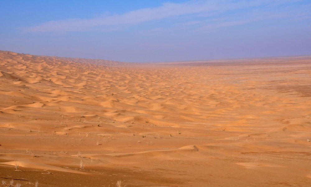
We make our way to the desert to a land that is not the ultimate to be loved and perhaps the vastness of the desert that demands such love. The group begins a shepherd gas station in the northeast of Isfahan province. After filling the car tanks and towing, we head towards the village of Hemmatabad, southeast of Rig Jen. Hemmatabad is a deserted village used for camel keeping. The village is the last symbol of civilization in the east of the Rig Genie. At a distance of 2 kilometers Hemmat Abad the road turns north and we turn off the dirt road and continue west to reach the seasonal river. Due to recent rainfall the river is seasonally full of water and has blocked the passage. We continue northwest along the river until the river flows into the desert and paves the way. After crossing the river we continue west and Fifth Alley to the Rig. On the south side is the sand dunes of the Jinn, and on the north side is a puffy desert, which is partly puffy but not glacial due to the rainfall. This makes it easier to cross these lands. Cars in these deserts need to be alternated and the leading car is constantly changing so as not to put too much pressure on the car. After a distance of about 3 kilometers, we run on top of a sand-covered hill. The weather is extremely cold and promises a tough stay in the sand jungle. In the coldest time before dawn, it reaches zero below zero degrees.
Day 2 Move to Fifth Avenue Rig Jen
After a relatively cold night and watching the 4 wolves cross the camp, we are ready to move. After breakfast we continue west. We descend the steep sand slope to reach the desert surface again. Within a distance of about 3 kilometers, we reach the fifth alley of the Rig Jen. Huge sand wall extending 5 km to the north. It is almost impossible to cross east to west due to the steep slope of the eastern front and the high altitude of the hills, and almost all the crossings have had an east-west direction. Some friends find a number of fossilized scallops to support the theory that the central desert of Iran is sea. Returning to the camp for lunch after returning to the camp. The sun is setting and the weather is a little colder than the night before. After lunch, we gather around the fire and review memories of past trips.
Day 3 Departure from Rig Genie
After a very cold night, we move to the east to collect garbage. After reaching the dirt road, we head north and exit the sand jungle. The next destination is Safi Bagher Dedzou east of Farahzad Village. The continuation of the dirt road is a very slow-moving traffic that cuts off much of the water and slows the movement of cars. After a distance of about 5 km we reach the shepherd’s communication axis and move to the beautiful village of Farahzad.


